


IMC to Hyannis:
An Exercise in Crew Coordination
1500 Hours or Bust
The push was on. I committed to myself last year that I'd fly at least 10 hours a month until I was within about 50 hours of the ATP Certificate's 1500 Hour Total Time requirement. At that point, I figured I'd transition from flying single engine to multi-engine aircraft in prep for the flight test. This meant a substantial commitment of both time and money, two things that always seem to be in short supply.
Over the past year, just like clockwork, I've checked in with my longtime friend and crew partner during the middle of the week to discuss our availability for the coming weekend's flight, and then again on Friday to discuss the weekend forecast. We've reached a point when we just say "see you <fill in the day>" and we show up at the same time, for the same mission (albeit to a different destination) each time. The mission is "reach the destination safely, and return". Sound boring? It supposed to be!
Boring Flights are the Best Flights
I love it when flights are boring. It's confirmation of everything I do as both a pilot and aircraft operator. From the weather analysis to the preventative maintenance, when a flight goes off without a hitch, I chalk it up to a lot of preparation, reasonable judgment, and safe operation of the aircraft.
One of the best ways I've found to operate the aircraft safely is through the use of a two pilot crew. Does a Cessna 172 need a two pilot crew? Of course not. I've done more than my share of single pilot IFR in it an other aircraft. But professional aviation (aviation done by professionals, whether they are flying for a salary or not) is more about safety than it is about the ego boost pilots get by meeting the sometimes exceptional challenges provided by single pilot IFR.
My longtime friend and crew partner and I have flown well over 300 hours together and have made a science out of our aircraft operations. We know almost to the tenth of a gallon how much fuel we burn, how long it takes to burn through a quart of oil, our power settings at nominal cruise...etc. all by heart. We have orchestrated the operating processes of aircraft operation to the point that if something strange happens, we notice and react to it immediately. And, if by chance one of us doesn't notice an unsafe condition, the other is there as a backup. For us, every flight, even those that present new challenges, are, well...boring, and I wouldn't have it any other way.
Take, for instance, a recent trip to Hyannis, Massachusetts, by way of Hartford, Connecticut.
Synopsis
I usually take care of the weather analysis and brief my partner on the situation because we usually file under my name. No particular reason for that. My partner is instrument rated and qualified...it's just evolved like that over time.
Of course, this wasn't your typical VFR day, so it required some extra work. After a few yawns (hey, it was early and I worked late the previous night), the synopsis tells the story:
STG SHRTWV TROF ERN IA-SW MO WL ROTATE EWD INTO THE ERN OH VLY BY 00Z. WK LOW IS OVR SERN MD WITH STNR FNT NEWD AND STNR FNT SWWD TO WRN SC. LOW WL DSIPT BY 18Z AS WILL SN PTN OF THE STNR FNT. CDFNT EXTDS FM SRN WI_SERN MO AND WL MOV EWD RCHG WRN OH-CNTRL KY BY 18Z AND WL EXTD FM SERN ONT-WRN PA-NW NC BY 00Z.
We're in between a seemingly unending chain of storm systems with a stationary front to our south, a hundred or so miles offshore, roughly paralleling both the coastline and our route of flight. Stationary, of course, really means less than 5 MPH in any direction, which generally means that weather will change more slowly (or perhaps more predictably). That's a good thing (tm).
For our departure from central New Jersey, the state-specific portion of the FA enlightened us:
NJ...OVC010-020. TOPS 040. OCNL VIS 3-5SR BR. 16-18Z BKN015-025 OVC030. OCNL VIS 4-6SM BR. OTLK...MVFR CIG BECMG IFR CIG BR AFT 00Z.
The forecast covering eastern portion of our route and both airports of intended landing went on to say:
MA RI CT
ERN SXNS...OVC010-020. TOPS 040. BKN CI ABV. OCNL VIS 3-5SM BR.
18Z BKN015-025 OVC030. OCNL VIS 5SM BR. OTLK...MVFR CIG BECMG
IFR CIG BR AFT 00Z.
This is a classic picture of good IFR training weather. Just enough low stuff to make things interesting, but not so low as to challenge our ability to return to our home base (served only by a non-precision approach), or our alternate fuel requirements, and tops low enough that we'd be able to get on top given our planned flight profile just in case we experienced instrument failure. We also had an "out" if the weather along the route turned out worse than forecast. About only 30-50 miles to the northwest of our departure airport, as well as 75-100 miles north of the our two destination airports, current METARs were indicating MVFR to VFR with scattered to broken clouds at at 2000-3000 feet.
The low, but relatively thin overcast deck, obviously formed as a result of the rain we'd received over the past couple days. There was a ton of low-level moisture with nowhere to go but up in the process of evaporation. Since the front was to our south, and generally supporting a westerly to northerly flow aloft, there was sufficiently dry air above 4000 feet to make for a near cloudless sky above this deck.
Definitely doable weather.
The Best Forecast...the Nowcast
Of course, the Area Forecast is exactly that: an AREA forecast. It often lacks the specifics of local terrain and water influence. The best forecast is only valid when backed up with current observations.
For our departure:
METAR KBLM 081055Z AUTO 05004KT 3SM FEW003 SCT035 BKN047 14/13 A2990
METAR KTTN 081053Z AUTO 02003KT 4SM BR OVC005 15/14 A2987
First lesson in judging weather. Whenever you see a low scattered deck at 300 feet at one airport and an overcast deck at an adjacent airport at nearly the same altitude, and the temp/dewpoint spread at both airports clearly supports the formation of clouds at that altitude, you can safely surmise one thing: the scattered deck could easily go Broken or Overcast. Therefore, for planning purposes, you should assume you have an overcast deck at that altitude; in our case variable between 300 and 500 feet. Think Trenton's observation is a fluke? Here's McGuire AFB' observation. They're just to the south of Old Bridge.
METAR KWRI 081055Z 03004KT 3/4SM RVRNO -DZ BR BKN002 OVC004 15/15 A2986
Check out that temp/dewpoint spread. That is a believeable 200-400 overcast deck, particularly because if the ASOS was reporting something inconsistent with reality, the tower controllers would amend or correct the observation. ASOS is great, but it isn't always as believable as a human being.
Fortunately, our first destination, Hartford CT is painting a better picture.
METAR KHFD 081053Z 01006KT 6SM BR OVC010 15/14 A2987
Another pattern emerges. The altimeter setting is consistent within 3 one-hundredths of an inch. That means a relatively constant wind velocity across the route (keeping in mind that doesn't necessarily mean the wind will be calm or 30 knots...just consistent).
But what's this?
METAR KHYA 031056Z 04009KT 2 SM BR OVC002 13/13 A2984
A solid 200 overcast at Hyannis with a temp/dewpoint spread that confirms the low IFR. Normally, I'd question going to Hyannis, but a quick check of the forecast shows an an improvement for our arrival sometime around 18Z. Of course, the improvement will be short lived, as the classic Cape Cod Fog will be back by 8PM that night.
TAF AMD KHYA 030643Z 080706 02011KT 1SM -RA BER OVC002 TEMPO 0711 4SM BR SCT004 OVC020
FM1200 03012KT 3SM BR OVC012 TEMPO 1216 3SM -DZ BR 0VC004
FM1600 04010KT 5SM BR OVC020
So, weather now agrees with the forecast, and it IS forecast to improve. Given that we have VFR on tap to the north, and Hartford is reporting reasonable weather that also agrees with its forecast, I make the call to "go". Worst case, Hyannis stays at 200 ft and we get an opportunity to fly an approach to minimums and fly a "real" missed approach procedure.
Of course, I don't have to call my crew partner to tell him that, because he knows that unless I call in the morning to tell him to stay home, we're going.
Preflight
Since I usually do the preflight planning, my partner usually arrives at the airport a few minutes earlier than I do, opens the hangar and begins the preflight inspection. On this particular flight, I was a few minutes late, and he had completed the inspection by the time I managed to drag my overweight flight case to the hangar door. After the usual greetings, we got down to business and he started the simple, but effective communications process known by successful crews everywhere. "48 gallons, oil is at 6".
Of course, that's my cue to check the oil for myself to confirm his assessment and do my own acceptance analysis of the aircraft. This is not reflective of a lack of trust of my crew partner: quite the contrary. Rather, it's all part of the continuous cross-checking and validation that goes on between crew members.
If there are any squawks (we try hard NOT to have those), we discuss them at this point. I brought up our recent work on the aircraft and my well-intentioned, but unsuccessful effort to eradicate a gremlin from our vacuum system that had plagued us with a low, but stable, vacuum reading for the past year. We'd flown many times VMC and IMC with this problem, but since the departure airport was IFR and this was the first flight of the day, we talked about our worst-case scenario - a vacuum system failure on departure after we had entered in the clouds.
We agreed to have both the Old Bridge GPS/VOR and nearby Trenton Airport ILS approach plates on the yoke clips. We also agreed that barring any unforeseen circumstances, we would prefer to shoot the approach back into Old Bridge. Given that, and the fact that my partner was serving as the Pilot Flying (PF) today, he'd get the Old Bridge plate on his yoke clip, and I'd put the Trenton plate on my clip as a backup.
After a quick acceptance check of the VOR receivers and other paperwork, we pulled the aircraft out of the hangar and I went about calling McGuire Clearance Delivery while my partner went back to button up the hangar.
Startup
While I was waiting for McGuire to come up with something resembling our filed route, my partner hopped into the left seat, buckled himself in, and silently ran through the flow to satisfy the Before Starting checklist.
By the time he was done with that, I was reading-back our clearance to McGuire. My partner always listens to the readback to catch the squawk code, which he then plugs into the transponder. The preferred route to Hartford is well known to both of us, so after I got off the phone, I gave an abbreviated route briefing indicating we were to fly the "standard route" and 7000 feet, at which point my partner began the Starting Engine flow and checklist.
During this time, I backed him up on his "clear prop" check by looking around my side of the aircraft and, in particular, behind us. After I was done and called"all clear", he engaged the starter. Soon after the engine settles into a 1000 RPM idle, my partner pulls the mixture lean in prep for warmup and taxi, while I call "Oil Pressure Rising, EGT rising, Ammeter charging".
After a quick check of the electrical system profiler and we confirm that voltage is within the acceptable range while charging, we reach for the Avionics Master switches. One is located on my side of the cabin and the other on his simply due to panel real estate issues, so we each actuate the switch closest to us and the stack comes alive.
Ground Check != Before Takeoff Check
Once the After Start checklist was complete, we started to taxi. While my partner's fancy footwork took us to the runup area, I turned the knobs on the Garmin 430 to bring up a stored route from 3N6 to HFD. I reviewed the route to confirm it matched our filed route (it did this time, thankfully), and briefed my partner on the initial course and altitude. This constituted our departure briefing.
Incidentally, the ground check is done by the PF completely from memory. When done, the PF calls for the Ground Check checklist, the PNF runs down the checklist items and, as with all checklists, eventually calls "Complete" to indicate there are no items remaining. This ensures undivided attention to the checklist until all items are completed.
 After
the Ground Check, we move on to the Before Takeoff check, which
includes all of the things you'd expect to check before a
takeoff. This sounds a bit stupid until you realize that the
distinction between a Ground Check and a Before Takeoff check is
important. A Ground check occurs once per flight session, while a
Before Takeoff check occurs before each takeoff. Most pilots
don't think about this because they're used to flying with the
factory checklists that don't take this simple fact into
account.
After
the Ground Check, we move on to the Before Takeoff check, which
includes all of the things you'd expect to check before a
takeoff. This sounds a bit stupid until you realize that the
distinction between a Ground Check and a Before Takeoff check is
important. A Ground check occurs once per flight session, while a
Before Takeoff check occurs before each takeoff. Most pilots
don't think about this because they're used to flying with the
factory checklists that don't take this simple fact into
account.
After the Before Takeoff checklist is complete, the PF will typically give a takeoff briefing, which outlines the takeoff type to be executed as well as the expected handling of emergency operations in during the initial phases of flight.
In a twin, this briefing involves discussions of airspeeds, since the go/no-go decision after an engine failure has everything to do with airspeed. In our Skyhawk, however, the standard brief involves the declaration of a fail-safe altitude, above which we might try to return to the airport, and below which, we'll land straight ahead or turn up to 90 degrees to land at a known nearby off-field landing site. If we don't know the airport vicinity that well, or there simply aren't any decent landing sites within a mile radius of the airport, the briefing will typically declare a turn into the wind to reduce our ground speed at the point of impact...wherever that might be. Not particularly pleasant to think about, but it's better to think about it now than have to think it up on the fly and possibly put the aircraft and passengers at greater risk.
Into the Wild Gray Yonder
When holding short for takeoff about two minutes before our release time, my partner called for the In Position check. Doors Closed/Latched, Boost, Landing Light, Transponder ALT and we're ready for my radio call. "Old Bridge Traffic, Skyhawk departing 06, southeastbound, Old Bridge". If you're wondering about the significance of two minutes, well, that just so happens is the time it takes for us, on average to takeoff and climb to enter controlled airspace.
Standard procedure in our aircraft is to line up on the centerline and smoothly bring the power up. As the tach reaches 1800, we hold the throttle there briefly to check our manifold pressure and engine gauges. For departures at Sea Level, manifold is approximately 18 inches, so the standard call the PNF makes is "18 and 18, gauges green". If the PF hears that, he releases the brakes and smoothly brings the power up to full throttle and 2700RPM. Fortunately, this takeoff was like every other I've had in this aircraft as of late, and went off without a hitch.
We encountered the first few clouds at approximately 900 feet, which was great because at that instant I knew we had a safety margin of approximately 500 feet above the minimums for the GPs approach in case we needed to turn around.
 Courtesy of the Garmin
430, our clearance was direct to DIXIE, then V16 to JFK, and
finally V229 all the way up to the Hartford VOR. Since the
airspace above 2000 feet over Old Bridge belongs to New York
Approach, McGuire usually keeps us at 2000 until within the
lateral boundary of the V276 airway. At that point, McGuire owns
up to 8000, so we were soon cleared to 5000, our final cruising
altitude. We broke out at about 3800 feet and gave a base/top
pirep to McGuire before they turned us over to New York on
124.95. Of course, I knew that frequency because I had written it
on the chart some time ago.
Courtesy of the Garmin
430, our clearance was direct to DIXIE, then V16 to JFK, and
finally V229 all the way up to the Hartford VOR. Since the
airspace above 2000 feet over Old Bridge belongs to New York
Approach, McGuire usually keeps us at 2000 until within the
lateral boundary of the V276 airway. At that point, McGuire owns
up to 8000, so we were soon cleared to 5000, our final cruising
altitude. We broke out at about 3800 feet and gave a base/top
pirep to McGuire before they turned us over to New York on
124.95. Of course, I knew that frequency because I had written it
on the chart some time ago.
At 500 feet before our cruising altitude, I glanced at the power charts and announced "Cruise Power 5000 21/23", so my partner would be able to configure the airplane properly for cruise and then call for the "Cruise Check".
The cruise check is just like all the other in-flight checklists: they are utilized as true CHECKlists, rather than DOlists. If an item is called on the checklist and it is not in the correct position, the PNF is expected to raise a flag and correct the PF. Since we're both perfect pilots, with perfect memories, that never happens. Uh, yea, right. That's what checklists are for!
It didn't take long for us to take note of how quiet all the frequencies were. Clearly, the weather was keeping the vast majority of the general aviation population on the ground, but frankly, we couldn't understand why. This was fun stuff! We heard a lone 182 climbing up behind us, but everyone else on frequency was heavy iron.
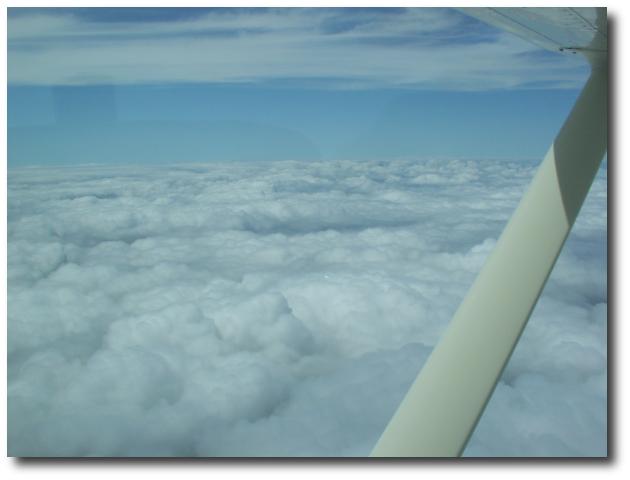
As we tooled up V16 toward JFK, New York called out a stream of departures from Kennedy that would just pop out of the clouds and hug the tops until turning southbound for their climb. They were easy to spot, so I took a snap of one (photo journalist is among the PNF duties as well, if you hadn't guessed!). :-) The most impressive aspect of the flight was summed up by that picture. Without any visual contact of the world beneath the clouds, for as far as the eye could see, when the radios went briefly silent, it felt like we were the last people on earth.
Welcome to Hartford
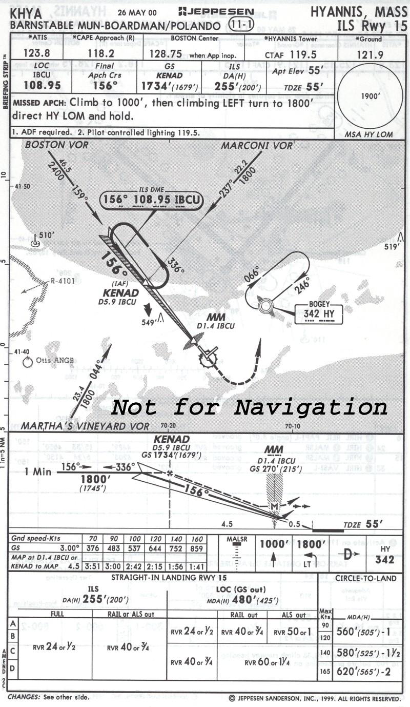
It didn't take long before we had picked up the Hartford ATIS, which reported 1200 Scattered, 1400 overcast and visibility of 2 miles -- reasonably close, but slightly below forecast. They were using the LDA02 approach, so I flipped the knobs on the Garmin and selected that approach. Since we weren't arriving on an airway or other feeder fix, I also selected a Vectors transition. After I had set up the approach and identified everything, I suggested we do the approach brief, which went something like this:
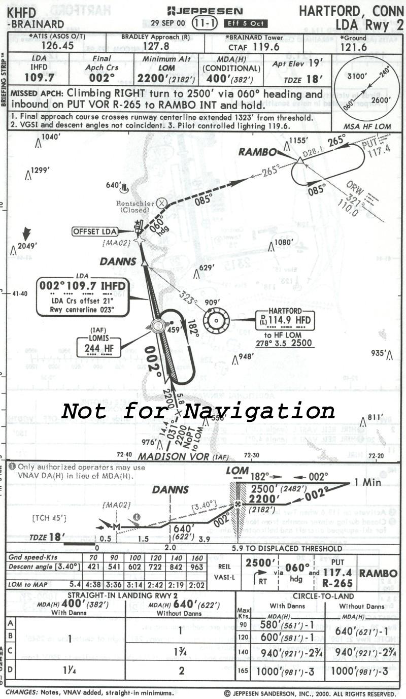 "Okay, we'll be
shooting the LDA 2 to the Hartford Airport, elevation 19 feet.
The final approach course is 002 degrees, which is offset 21
degrees from the runway centerline. We'll approach the runway
from the east, so we can expect to see the runway just to the
right of the nose and we'll need to make a gradual right turn to
land. The LDA frequency is 109.7, tower is 119.6. The final
approach fix is the LOMIS compass locator / outer marker. We can
identify DANNS, so our MDA is 400 MSL (approximately 380 AGL).
We'll use GPS to identify DANNS, but I've setup CDI2 as a
backup."
"Okay, we'll be
shooting the LDA 2 to the Hartford Airport, elevation 19 feet.
The final approach course is 002 degrees, which is offset 21
degrees from the runway centerline. We'll approach the runway
from the east, so we can expect to see the runway just to the
right of the nose and we'll need to make a gradual right turn to
land. The LDA frequency is 109.7, tower is 119.6. The final
approach fix is the LOMIS compass locator / outer marker. We can
identify DANNS, so our MDA is 400 MSL (approximately 380 AGL).
We'll use GPS to identify DANNS, but I've setup CDI2 as a
backup."
I then asked for my partner's preference for approach speed. When he said 100 Knots, I continued the briefing...
"The approach timing for 100 knots is 3:14. If we go missed, we'll start a climbing right turn to the northeast on a 060 heading, up to 2500 to intercept the 265 radial from Putnum VOR inbound to the RAMBO intersection for a hold with left turns. We can expect to use a teardrop or parallel entry. Any questions?"
After the brief was done, my partner called for the Approach Checklist, which we then completed. About that time, New York handed us off to Bradley, and I checked in..."Bradley Approach, Cessna 9803C, Level 5000, Quebec, Request Vectors LDA 2". Bradley greeted us with a descent and vectors to the LDA 2, and in short order we were riding the LDA inbound. We entered the clouds at approximately 3300 feet and descended to 1400 before breaking out under a dreary gray overcast...a marked change from the bright sun we'd been enjoying for the last hour.
A Mission to Accomplish
We stopped again at Atlantic Aviation and received great service with a great fuel price. Of course, the place was dead, so there was no wait. I went upstairs to the pilot lounge/briefing area and looked ahead to our next stop, Hyannis. The latest forecast told an interesting story...
TAF KHYA 081432Z 081512 02007KT 5SM BR BKN002
OVC020
FM1600 04010KT 5SM BR OVC020
FM0000 04005KT 1/2SM FG OVC002=
This suggested that in another 15 minutes (at 16Z), and certainly by our arrival time in another 1+30, any reasonable person might expect the 200 overcast deck to dissipate until later that night. The observation trend, however, told another story:
METAR KHYA 081540Z 01011KT 2SM BR OVC002
13/13
METAR KHYA 081533Z 02008KT 1 3/4SM BR OVC002 13/13
METAR KHYA 081522Z 02009KT 2SM BR OVC002 13/13
METAR KHYA 081456Z 01008KT 3SM BR OVC002 13/13
METAR KHYA 081356Z 02007KT 5SM BR OVC002 13/13
This simply confirmed what I learned 10 years ago flying back and forth to eastern Mass. Cape Cod serves up persistent foggy conditions like few other places in the world. I saw no significant change in all of these observations, so I assumed at this point that if we did continue on to Hyannis, we'd very likely fly the approach to minimums, and have a better than average chance of going missed.
I didn't like the idea of turning our tail and going home, so I figured if we tried and did wind up going missed, at least we'd be able to log an ILS to minimums...something weather rarely permits on a regular basis but something that does wonders for a pilot's comfort level in IMC. Having a war story or two to tell wouldn't hurt either. :-)
 In fact, that's
what I told my crew partner when I found him downstairs. He
agreed with my logic (and agreed the war stories might be fun to
tell...someone other than his worrying wife), so we decided to
launch to Hyannis as scheduled at 16Z. After all, we had a
mission to accomplish.
In fact, that's
what I told my crew partner when I found him downstairs. He
agreed with my logic (and agreed the war stories might be fun to
tell...someone other than his worrying wife), so we decided to
launch to Hyannis as scheduled at 16Z. After all, we had a
mission to accomplish.
Back in the Soup
After a short departure delay required by Bradley, we were soon in a climbing right turn to a heading 120 for radar identification. We popped out of the clouds at just over 3500 feet and again climbed to 5000 before we were given a turn on course to Providence. The climb went by the book and before we knew it, we were talking to Providence Approach.
Before we were able to pick up ATIS, we discussed our approach options. We figured they'd be using runway 6 since the winds were from north at about 11 knots, and the observation trend generally suggested an increase in wind speed. The obvious problem was that the only available approach for that runway was the VOR/GPs 6: its MDH of 514' just wouldn't cut it. If the ceiling remained low, we were guaranteed a missed approach.
The next most likely choice was using the ILS 24. That would be downwind, but manageable. The problem? DH was 250'. If the ceiling stayed at 200 feet, we would still have a high probability of going missed on that approach too.
As we neared Providence, we were finally able to pick up the Hyannis ATIS, which made the decision for us. They were using the ILS15, landing downwind with a 8KT tailwind component. The good news? The approach sported a standard 200 foot DH. Heck, we thought...with a bit of luck (and skill), we might just make this work.
Given that I thought this would turn out to be the lowest approach I'd ever made in 15 years of flying IFR, I was determined to set the proper tone for the approach segment. During the approach brief, I told my partner I expected we'd fly the approach to minimums and then fly the published missed. I figured we had about a 40% chance of getting in (though I didn't dash the hopes of my partner by saying that...I kept that little factoid to myself!).
Providence Approach soon turned us over to Cape Approach and the controller running arrivals into Hyannis. We listened intently for a few minutes to figure out if anyone was going into Hyannis but didn't hear anything of value. I then asked the controller if he had anyone get into Hyannis in the last hour. He then told me about a Citation he had on vectors for the approach. I then said "Approach, 03C, we'd appreciate a base report from the Citation inbound to Hyannis". The controller responded and as he turned the Citation into the localizer a few minutes later, we heard him ask the Citation "I'd appreciate it if you would relay a base report to the tower upon landing, contact the tower now, 119.5, good day".
 By this time, I
had provisioned the Garmin for a Vectors transition to the ILS 15
and the controller cleared us from 3000 feet down to 1800 feet
for the final vectors to the final approach course. As I started
to bring the Garmin's moving map scale down to 10 miles, it
looked like we might be a bit late on the final vector (man,
moving maps are so cool), so I called the controller and asked
him whether he intended to take us through the final. Although we
were still about 6 miles outside of KENAD, we were still
descending and a bit fast, so I figured it was a legitimate
question. He immediately came back and said "Cessna 03C, turn
right and intercept the localizer".
By this time, I
had provisioned the Garmin for a Vectors transition to the ILS 15
and the controller cleared us from 3000 feet down to 1800 feet
for the final vectors to the final approach course. As I started
to bring the Garmin's moving map scale down to 10 miles, it
looked like we might be a bit late on the final vector (man,
moving maps are so cool), so I called the controller and asked
him whether he intended to take us through the final. Although we
were still about 6 miles outside of KENAD, we were still
descending and a bit fast, so I figured it was a legitimate
question. He immediately came back and said "Cessna 03C, turn
right and intercept the localizer".
Just as we reached 1800 feet the localizer needle started to move and I called "localizer alive, looking for 100 Knots". My partner complied and slowed the aircraft to our final approach speed. From this point on, we'd maintain that speed until 500 feet above minimums as I briefed earlier. Then the call came. "Cessna N9803C, three miles from KENAD, maintain 1800 until established, cleared ILS15 approach, contact the tower now 119.5".
Then the fun began.
"Hyannis Tower, Cessna 9803C, 2 miles outside KENAD, ILS 15, Good afternoon". The controller cheerfully came back with "Cessna 9803C, good afternoon, cleared to land 15, report KENAD". I then acknowledged the call and refocused my eyes on the approach.
All unnecessary discussion had long ceased, so aside from my incessant PNF-type feedback, the cockpit was silent. Shortly after crossing KENAD and reporting that to the tower, I went through the landing checklist and began my routine altitude reports.
"1000 to minimums". I noticed he was a bit fast (obviously the result of pushing the nose over to capture the glideslope without removing enough power), so I said "plus 10". I watched with satisfaction as he pulled the throttle back and the airspeed dropped to 100 Knots, the localizer and glideslope needles centered and he proceeded to execute a "broken CDI" ILS.
Before I knew it, I had called "500 to minimums". He started to reduce power and pitch up slightly, all the while maintaining glideslope and getting us into a position to add flap if necessary. A short time later, at a mere 75 feet above minimums, I caught the first ground contact. The flight visibility was surprisingly low, but that was obviously due to the fact that we were just emerging from the bases. I immediately called "ground contact" and started looking for the runway, which quickly came into view slightly to our right. At that point I called "Runway in sight". My partner acknowledged he also had the runway, and then gracefully tweaked the alignment of the aircraft a few feet to position it precisely over the centerline.
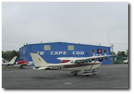 As we descended to 50
feet above ground, it quickly became evident that we were easily
10 knots downwind, so I offered full flaps to allow us to touch
down as slowly as possible, and we both breathed a welcome sigh
of relief as the aircraft touched down smoothly, slightly after
the fixed distance markers. After answering the controller's
request for a destination on the field, he told us to taxi the
full length of 15 and turn left to taxi to Air Cape Cod "on
frequency". After we pulled off the runway, I looked over at my
partner, gave him the "thumbs up" and told him he'd done
good!
As we descended to 50
feet above ground, it quickly became evident that we were easily
10 knots downwind, so I offered full flaps to allow us to touch
down as slowly as possible, and we both breathed a welcome sigh
of relief as the aircraft touched down smoothly, slightly after
the fixed distance markers. After answering the controller's
request for a destination on the field, he told us to taxi the
full length of 15 and turn left to taxi to Air Cape Cod "on
frequency". After we pulled off the runway, I looked over at my
partner, gave him the "thumbs up" and told him he'd done
good!
Anticlimactic Ending
After fueling up and reviewing the weather for the trip back home via Hartford, it became pretty clear that we'd seen the worst of the weather. Sure enough, the ATIS departing Hyannis revealed the ceiling had risen to the dizzying height of 400 feet. With a strange sense of satisfaction, I wondered where that forecast 2000 overcast deck managed to hide. Cleared for takeoff, we entered the clouds at approximately 400 feet and broke out to the northeast of the airport over water at approximately 1500 feet.
We wound up shooting a GPS-A approach into Hartford so we didn't have to wait in as long of a line for the LDA 2. During vectors, the controller put us at 4000 feet, just skimming the tops of the clouds. The sensation of "buzzing" the clouds at maybe 50 feet gave us the opportunity to imagine we were flying a far faster aircraft (hey, 115 KTAS DOES get boring after a while!), so I had some fun at the controls while my partner took a well-deserved break. We broke out at 1200 feet, landed, were quickly turned around by Atlantic again, and then took off for the final leg home. Some unfriendly winds kept us in the air for 1+25, but we still managed to touch down within five minutes of our scheduled ETA.
My crew partner was in a hurry to get home for a family obligation, so I stayed behind to tend to the post-flight inspection, paperwork, and cleaning. The time alone gave me a chance to reflect on what we'd just accomplished, and revel in just how exciting a boring flight can be!