


Icing Encounter
Ice is where you find it!
One Saturday in early March, I decided to fly with a friend and copilot up to Schenectady NY (SCH) via Danbury, CT (DXR). This is a brief account of how this turned out to be one of the shortest IFR flights I've had in a long time.
January 2004 Update: Another run-in with icing conditions drives home several of the points learned previously.
Weather Analysis
I began this flight like I begin every flight...with a thorough planning session the prior evening. I began by using the resources provided by ADDS, the best weather dissemination tool to hit aviation since the Flight Service Station. I followed up by using the DUAT service to log an "official" weather gathering session and to review Notams and TFRs.
At this point, I noted that the forecasts generally called for between 6000-8000 overcast throughout NJ, southeastern NY state, and New England. The winds were forecast to be light and variable at the surface, less than 10 knots from the west at 3000, and perhaps 15 knots from the same direction at 6000. All in all, it looked like a good, if not ideal, winter day to fly VMC on an IFR flight plan before more icky weather was slated to arrive on Sunday. Just before midnight I filed four IFR flight plans with my friends at the Millville AFSS and went to bed.
I woke up early the next morning to see current and forecast conditions calling for around 5000 overcast with a greater chance of lower ceilings (averaging 3500 broken to overcast with a chance of 1500 scattered) to the west and south of NJ. Light rain was forecast near my base only after 4PM, after which a ceiling of 2000 overcast was likely throughout NJ. Certainly not low IFR by any means, but this was my first clue - a scattered deck at 1500 feet means there is sufficient moisture at that low level to produce clouds, which generally means a nicely saturated airmass near the bases of the next higher cloud layer.
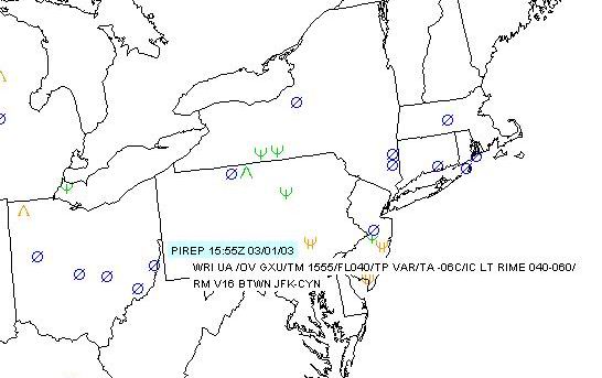
The only red flag in the whole forecast was Airmet Zulu:
BOSZ WA 011445
AIRMET ZULU UPDT 2 FOR ICE AND FRZLVL VALID UNTIL 012100
.
AIRMET ICE...NH VT MA RI CT NY LO OH LE PA NJ WV MD DE AND CSTL
WTRS FROM 70SW YOW TO CON TO BOS TO HTO TO SIE TO EMI TO CVG TO
FWA TO DXO TO 70SW YOW OCNL MOD RIME/MXD ICGICIP BLW 110. CONDS
SPRDG SLOLY NEWD AND CONTG BYD 21Z THRU 03Z.
.
FRZLVL...SFC-040 N OF A CVG-15S AIR-20W EMI-40S SIE LN SLPG TO
040-080 RMNDR AREA.
As you'll note in any such airmet, it says "...in clouds and precipitation". This generally means if you stay out of the clouds and precipitation, you'll stay out of the ice. Right? Like so many things in life, that "depends".
Because going to SCH would have brought us back to the area near 4PM and the general picture portrayed deteriorating weather after 4PM, I quickly scrapped plans to do the second leg, and instead determined that it should be possible to do a quick hop to Danbury and back with both current and forecast ceilings in the neighborhood of 5000. Some might consider that a good VFR day, if it were not for the foggy conditions keeping visibilities in check around 5 miles.
Before I left the house I called Millville to get a last minute check on the Notams and TFRs, and to make a few flight plan modifications (including canceling the DXR-SCH and SCH-DXR plans so I didn't generate strips).
Departure and Climb
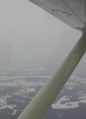
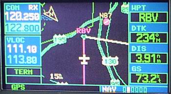
The departure and climb were as expected. Visibility was generally around 5 miles as we headed direct to the Robbinsville VOR at 2000 feet. At the VOR, we received a clearance to climb to 4000 and began our turn to the north toward the Solberg VOR. Although we had ground contact at all times, I did noticed the passing thin scattered deck at around 1500 feet. Second clue - technically, that deck shouldn't be here until much later in the day.
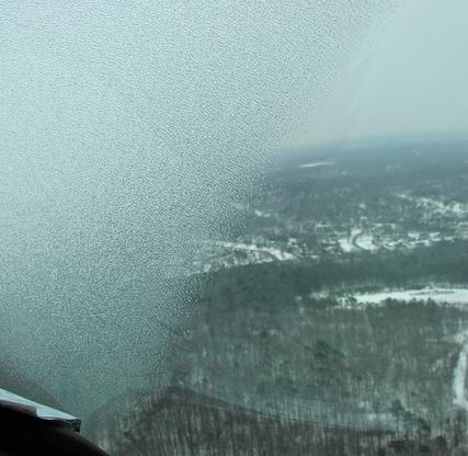
We reached cruising altitude a few miles north of RBV and shortly thereafter received a frequency change to New York Approach. Once we checked in, I started noticing a slight covering of what I thought looked like the usual moisture that can form on a window when flying in high moisture conditions. I glanced up at the OAT gauge and found it hovering at -6C, glanced back at the window, then out at the leading edge, and then back at my copilot. At that point I solicited my copilot's attention for monitoring the formation of ice on his side of the airplane.
Right about this time, I wondered why my copilot's heading-tracking skills appeared to need a little work. Then I noticed him resetting the DG. It was some 20 degrees off.
While this DG is every bit of 30 years old, it's been rather reliable...that is, until the last flight (the first flight since the airplane returned from the avionics shop). I noticed the DG precessing at a somewhat higher rate than we'd come to expect, but it was well within the recommended maximum and I didn't think much about it. I wrote up a squawk in our flight manual maintenance logs as a point of reference and asked my avionics rep to get a quote on a new gyro, figuring we'd replace it before it got any worse.
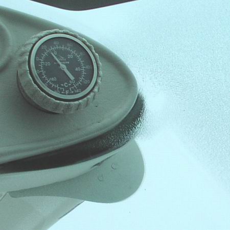
Within 5 minutes I noticed my copilot reset the DG again. When he released the adjustment knob, I watched in disbelief as the DG slowly rotated at a rate of about 1 degree a second to the left. A quick check of the mag compass and the AI confirmed we were straight and level. "That's not good!", I proclaimed.
At that point, the decision was made. We were going to abort this flight now, before we got too far away from home. And that was about it. There was no stress. In fact, I was joking with my copilot about various things all through this. I called ATC in my usual calm voice and let them know we had experienced a Directional Gyro failure, but had ground contact, and requested a turn back toward RBV VOR in preparation for a VOR approach (just in case that 1500 foot scattered deck we saw not 15 minutes ago had suddenly decided to go broken).
New York quickly responded my request and sent us back to McGuire Approach. Then I heard something that changed the tone in the cockpit. Above us at 6000 feet a guy made two urgent requests for a lower altitude within a minute,justifying it by informing the controller (and indeed all of braving the weather in that part of NJ that day) that there was moderate to severe mixed icing up there. As my copilot flew the airplane toward Robbinsville, I volunteered that we were picking up a trace to light clear ice at 4000 with an OAT of -6C, but by that time we were already on our way down to 2000 in preparation for a turn direct to the airport for a visual approach. Not surprisingly, shortly after my report, two other pilots, one cruising at 6000 and another at 4000, reported similar findings. Monkey see, Monkey Do.
On the descent, I noticed that my view out of the far right side of the front window was fine, but I couldn't see anything straight ahead. Fortunately, the defroster vent on the pilot's side did its job and cleared a nice section the full height of the window so that my copilot had a more than adequate view in front of the airplane. Nearing 2000 feet, the ice began to recede, my copilot reported the field in site, and I thanked the controller for her help and canceled IFR.
We landed uneventfully, though we did get some stares from a couple people while taxiing, obviously looking at our airplane's (decidedly bad) impression of an ice cube.
When we pulled up in front of the hangar and finally got out to take a look, I noticed that although the ice had already substantially melted, there was still a solid 2-3mm on the leading edges. It was still dripping off the airplane when we closed the hangar door a good 30 minutes later.
Lessons Learned
This is not my first ice encounter, and something tells me, no matter how well intentioned I am, it won't be my last. Unless you lock your airplane in the hangar from October to April around these parts, you're bound to experience it once in a while.
I also must acknowledge that this was not my worst encounter either, but it was my first bout with the clear variety. One thing is sure -- no matter how long you fly, you'll always see and learn new things (which is probably why I fly in the first place). But, before you get the wrong idea about this article, please understand that it's in this spirit of learning (and teaching what I've learned) that I justified writing it.
The most important lesson learned during this flight merely confirms what I've known about ice for a long time. Ice is where you find it. It's not necessarily forecasted, and even if it is, it doesn't always stay within the boundaries of the forecast. It's also pretty clear to me that no forecast can be taken literally. For example, at no time did we enter clouds or encounter any visible precipitation, the two conditions necessary for icing as specified by the Airmet covering the region, but there was evidentally enough ambient low-level moisture within 500-1000 feet of the bases to accumulate on the airplane as ice. In other words, I think that we were technically between layers, even though the lower layer was virtually non-existant. The fact that the freezing level was around 1500 feet, and visibility dramatically improved below that is also probably a good indication of where the moisture-laden layer began.
I've also confirmed one of my long-standing beliefs regarding icing -- the absolute worst time to try "threading the needle" with regard to ice is when MIXED icing is forecast. In my experience, the conditions that produce mixed icing usually produce the most random distribution of ice type and rate of accumulation. While some pilots (admittedly, myself included) have been known to take the "Occasional Light Rime Ice in clouds and precipitation" winter icing airmet with a grain of salt (or two), it's definitely clear to me that forecasted or current reports of mixed icing need to be taken very seriously. If there is any hint of mixed icing, the wise pilot would stay on the ground. This is not to say that RIME ice will be any less unpredictable or potentially destructive, but that the conditions that produce MIXED icing seem to occur less frequently, and when they do...look out.

Lastly, I've confirmed that most pilots don't talk loudly enough about ice encounters for fear of incriminating themselves, and I really think that needs to change. I didn't feel it necessary to say much about our ice situation at first because it truly hadn't reached a level of concern at which I'd report it, and because we had another more pressing issue to deal with at the time. I did eventually volunteer that information both as a comfort for the guy above us (light clear is better than moderate mixed) and as a warning to others to stay on the ground. I can only imagine how many people (like us) have found themselves in a situation that could have been avoided had someone else reported the conditions earlier.
I think the moral of this story is that weather forecasts can change, and if you are thinking about entering a challenging weather environment, make sure you have an out (like we did with relatively high ceilings, visibilities, and a freezing level above the surface).
So, you're probably wondering...how short a flight was it? A mere 0.6 tach. Life sure does fly when you're having fun, right?