


TIS the season...
To shop for avionics!
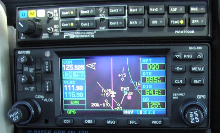
Garmin 430 w/ Mode-S Transponder Supporting "TIS"
As fall of 2002 gave way to winter, I made arrangements with my local avionics shop owner to get together to discuss options for upgrading a 10-year-old avionics stack in a friend's Cessna 172. I figured I'd put a article together to describe where we'd been, the results of my research into currently-available options, and where we decided to go in the future. If you're thinking of upgrading your avionics stack, you may find this article useful.
Humble Beginnings
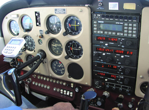
In 1992, I helped my friend search for a Cessna 172, and ultimately found this aircraft in the country northwest of Louisville, KY. The existing avionics package was the classic boat-anchor Cessna ARC series with mechanical frequency selection, with a few upgrades to (of all things) the ADF and transponder. In fact, the best thing in the panel was the transponder, but that too was an older vintage King KT76 (not the more modern -A model).
During the five hour flight back to New Jersey, we realized that most of the stack was out of tune - one communications radio was near unreadable to the many controllers with whom we spoke, the VORs were out of alignment (though one was barely within tolerance as I recall), and the ADF received but the bearing pointer was inoperative. In fact, the navigation equipment was in such poor shape that we ultimately wound up flying a combination of pilotage and dead reckoning with a GPS 100 AVD sitting on the glareshield. By the end of that long day, it was clear to both of us that after the inevitable catch-up annual inspection, we'd need to do something about this equipment.
We ultimately took the aircraft to a recommended local avionics shop. At the time, the owner was still working full-time during the week as a hardware engineer for a large corporation just outside of Philadelphia and part-time servicing old radios in a small space he had rented at the Perkiomen Valley Airport in Collegeville, PA. After a bit of bench time, the radios were brought back into specification. While they were not perfect, they served us well until the owner made the decision to upgrade the stack.
In 1994, we finally got around to upgrading the stack. Based on our favorable experience with Narco gear in the owner's other aircraft, we decided to put in a modern Narco stack in combination with a Garmin GPS 100 AVD.
That was then, this is now
If recent IFR flights have taught me anything, ATC now expects aircraft (large AND small) to be equipped with some form of RNAV gear (typically GPS), capable of going direct *anywhere*, including the airport.
While there is no legal foundation I am aware of for asking an aircraft to navigate direct to anything but well-established navigation beacons, and (if RNAV-equipped) intersections, ATC now routinely asks our C172/A to navigate direct to the airport for a visual approach. Years ago, ATC wouldn't have considered that we were able to navigate direct to the airport, but what was once verboten, is now commonplace. Clearly, times have changed, and we must change (our avionics) with them...again.
Avionics Lifecycle Cost
If 1994 doesn't seem that long ago, that's because it isn't.
Thanks due to in part to Garmin's revolutionary work, bringing what is essentially a specialized computer system into the General Aviation cockpit, subject to the supply of semiconductor parts with increasingly short production runs, owners are being forced to come to grips with the impact of Moore's Law.
The avionics lifecycle, which has historically been between 10-15 years, is definitely shrinking. I'd say it's now between 7-10 years, and I believe it will continue to shrink as both the FAA and the private sector bring new systems and services to the market. I can envision the lifecycle approaching that of the personal computer, where (for most people) equipment will find itself in the trash in as little as five years. Don't think so? I heard a UPSAT rep recently referred to their GX line of GPS navigators as "ancient technology" on which none of their engineering staff can justify working anymore. They started shipping a mere four years ago.
If you combine the increasingly rapid evolution of avionics equipment with what has to be the highest depreciation schedule of anything attached to the airplane (most avionics shops quote 50% value in only a year or two from the installation date), you quickly come to the conclusion that putting money into avionics is a losing game from day one. Therefore, we established our goal to upgrade the stack in order to provide the greatest increase in utility for the least amount of money possible.
Bread Crumbs
Sometimes, in order to know where you're going, you need to know where you've been. So, I figured I'd highlight our original stack and give our rationale for building it in the first place. As you'll see, some of it still applies, and some of it doesn't, which is why we were considering a new stack in the first place.
Our "1994" stack consisted of the following:
CP136M Audio Panel with Integrated Marker Beacon Receiver
We originally chose this panel because of price and one very nice feature the King equipment of the time did not have -- a marker audio mute with automatic reset. In slow aircraft, you can hear the outer marker audio for 15-20 seconds, and this can very distracting as you enter the final phase of flight, particularly when ATC expects you to report directly over the marker.
With a traditional audio panel, you'd most likely disable the MKR receive audio entirely until you passed the marker, but unless you remembered to enable the audio again, you'd likely miss hearing the middle marker. While this is less of an issue today as there is no longer a 50 foot DH penalty for an inoperative MM and therefore many MMs are being decommissioned, MMs are still prevalent, and it's definitely reassuring, particularly when operating near or at minimums, to hear an unmistakable confirmation of your position relative to the end of the runway.
GPS 100 AVD
This was, in my opinion, the finest GPS navigator of its day, primarily because of its ease of use. It's price-performance barrier would not be crossed until the advent of the GNS-series navigators. The best feature of this unit was its user interface. A close second was its natural ability to function on its internal NiCD battery pack for up to 5 hours in the event of electrical system failure. This navigator came with a shark's fin antenna that was far better than today's teardrop antennas at picking up satellites near the horizon. While it was certified for VFR-only, I would have graciously put my life in its hands under IFR in an emergency. It was that good.
COM810 Slimline communications transceiver
The decision to go with the 810 was primarily based on its reputation for reliability. Our avionics tech at the time was, like the shop owner, a skilled hardware engineer, and said that the 810 was one of the best designs he had seen. Given the number of units out in the field, he saw a surprisingly few come in for repair and upgrade. And, based on almost 8 years with the unit, I'd have to concur. To my knowledge, it's been on the bench once, and only to adjust sidetone.
MK12D+ Nav/Comm
This was purchased based largely on the success of the unit. The "+" at the end of the model number referred to a minor enhancement of the unit that would, shortly after setting a navigation frequency, supplant the standby frequency display with the current radial from the active VOR. This does come in handy, though I wish it was like the MK12E, NCS812, or NAV825 which provide a switch to change the display to show the bearing both TO and FROM the station.
DME890
This was a welcome addition to the stack, and a fitting backup to GPS, in the day where GPS had not yet achieved the FAA's blessing as a sole-source of navigation (for ANY GPS receiver). Now that GPS distance may legally substitute for all DME distances EXCEPT localizer DME, the DME is only really helpful in the event GPS as a whole becomes unavailable. While I haven't personally experienced a GPS outage since 1994, the very real possibility that GPS will become jammed or otherwise unusable during unusual circumstances justifies its continued presence in the average General Aviation stack.
NAV825 Slimline VOR/LOC/GS receiver
This receiver had actually been discontinued at the time we installed it, but it was a natural companion to the COM810, and we heard this unit had a reputation for reliability similar to the COM 810. The best feature of this unit for us was its glideslope receiver because this served as a redundant glideslope receiver. Some things change, and some things stay the same, and I suppose until the next generation of WAAS-enabled GPS receivers hit the market, allowing CAT I ILS-like approaches, two glideslope receivers will continue to be a nice perk.
KT76 Transponder
What can I say. This is the original transponder that came with the aircraft. Both it and the encoder we added to the aircraft shortly after its purchase were migrated to this stack. Until recently, it's been the most trouble-free unit in the stack. The unit fell out of tolerance this past summer, and the result was intermittent mode A and C replies as reported by more than one ATC facility. A bench session returned it to normal operation, but the tech questioned the rationale in investing additional money in a unit worth, optimistically, $250.
Gone Flying...er...Shopping...
We arrived at the avionics shop as scheduled one November afternoon to get a demo of the various gear available and to establish a roadmap for the installation. While I was already quite familiar with the GNS-series navigators and the various options applicable to an aircraft of this class, my friend was not, so the shop owner offered to pull his rather well-equipped Bonanza out of the hangar to give us a real-world demo of the equipment we were considering, and more.
I started by telling the shop owner that we had the following goals:
- install an IFR GPS in order to allow us to file /G,
- replace the aging KT76 transponder before it started to cost us more money than it was worth, and
- replace an aging (and downright obsolete) Sigtronics intercom.
The first topic of discussion was, therefore, GPS.
C172/G
I had a phone and email conversation with the shop and others on the net regarding the option of simply replacing the 2" tall GPS 100 AVD tray with a similarly-sized used King KLN94 unit, but we couldn't find a used unit at a reasonable price.
To make things worse, I became aware of a limitation of the KLN94: it will apparently refuse to enter approach mode with an expired database. Now, I know what you're going to say...but there are more errors in current databases, and still more errors on paper approach charts than I'd care to think about. So, if I'm 800 miles from home without my laptop or internet access, and can't get my hands on the new database for the time being, the last thing I want the GPS to do is play daddy and tell me what I can and cannot do, especially when you consider that we have a NOTAM system to flag approach changes. I think $8-10K should buy us some leeway, and so it shall. It turned out that the price of a new KLN94 with a 209 indicator was within $2000 of the cost of the Garmin 430 with GI106A indicator so we made the decision to write a check to Garmin.
We then needed to pick a model that made the most sense for our specific aircraft. We briefly talked about the GNS400 (GPS only), but I suggested that because the Garmin unit is 2.6" tall, and the stack was full, no matter which Garmin model we chose, we'd need to eliminate at least one nav/comm from the rack. After I commented about the 430's ability to plug in navigation frequencies when an approach is selected and smooth the CDI transitions from enroute to approach (even when monitoring an ILS), the choice was narrowed to the 430 or 530.
Since the shop owner's Bonanza was equipped with a 530, we were able to view the differences between the 430 and 530 firsthand. The differences between the two are essentially the following:
The 530 provides:
- a larger, clearer LCD display
- automatic VOR/LOC identification (like the UPSAT radios)
- radial/distance information from programmable waypoint
- 135 degree arc track-up "EFIS-like" navigation page
- Fewer pages overall due to the increased information per page
- Simultaneous display of critical navigation info: TRK, DTK, ETE, GS (on the 430, you need to sacrifice one of the items (usually ETE) and flip to the second nav page to see the remainder, but when you do that, you can't see the moving map display)
These items come at the expense of an additional 2" of stack space and $3600.
Is it worth it? We determined no, primarily due to budget (if cost were no object, after all, we'd be flying a Citation), but also because:
- We had no plans to subscribe to a weather uplink service in this aircraft, so the display would truly be a perk.
- I felt the 430 was light-years ahead of our existing stack's capabilities and in spite of the fact that it doesn't take pictures well, the 430's passive matrix display is pretty large and clear in its own right.
- Given that the GNS series are almost 3 years old, it doesn't take a rocket scientist to figure out that Garmin is working on the replacement to the GNS line, hopefully with 64K color LCD displays (similar to the UPSAT gear) and perhaps even WAAS-enabled GPS receivers. Therefore, we figured it made little sense to invest $3600 more in what would eventually become a secondary nav/comm.
Truth be told, however, the Garmin units are not perfect. My real-world experience with them has convinced me that if you're good at twisting the knobs, it's a great "procedures" unit. It will give you outstanding lateral guidance, and effectively tell you where to point the nose. The problem (at least at this writing) is that they do so without regard to terrain. It is very possible that a pilot could, by watching the Garmin alone, slam his aircraft into a mountain and not know what's happened until he's looking at the pearly gates.
The shop owner told us that the 500 series will likely get terrain information sometime in 2003. The data will be stored in the spare datacard that (interestingly) is provided by both the 400 and 500 series navigators. Does this mean that the 400 series will eventually get terrain information as well? The jury is still out. Even if it does, however, I'm not sure how useful it will be on that tiny, 16 color display, unless they simply provide what most pilots need -- a terrain proximity warning anywhere from 1-2 minutes in advance. Guess we'll have to wait and see.
(POP)...t did you say?
When we had our 1994 stack installed, I decided at the last minute to install an intercom. The avionics shop had an older rev of a Sigtronics SPA400 intercom on the shelf that had been removed from another aircraft. The price was right, so we installed it. Little did I realize that this "older rev" had a flaw in its VOX circuit that would activate with a slight, but noticeable "pop" or "click". After 8 years of listening to that "pop", and dealing with its tendency to activate the VOX circuit during high ambient noise conditions such as the beginning of the takeoff roll, I figured we'd upgrade it.
The problem was the only intercoms worth anything were between
$800-1000 installed, and since they had larger faceplates than
the SPA400, I'd need to find a new place in the panel for it.
 We couldn't find
a suitable location, so our discussion turned to audio panels
with an integrated intercom.
We couldn't find
a suitable location, so our discussion turned to audio panels
with an integrated intercom.
Since there aren't many audio panel OEMs, this really boiled down to a choice between the Garmin 340 and the PS-Engineering product line -- specifically, the 6000 and 7000 series. The only audio panel of the three I'd flown behind was the Garmin and I told my friend that I thought it was a capable audio panel.
Some general differences between the units appear to be:
- Styling - Personally, I think the Garmin styling and ergonomics are better than the PS, but the shop owner said some people found the multitude of different sized buttons on the Garmin to be confusing. I'm not one of them.
- Installation - The techs say the Garmin tray and connector design is flimsy and difficult to work with while the PS line comes with both a solid tray and connector design.
- Manual vs. Automatic Squelch - the 340 and 6000 use traditional squelch controls. The 7000 utilizes a proprietary automatic squelch technology called Intellivox, and eliminates the squelch controls -- yes, you heard right...there are no pilot-adjustable squelch controls.
- Stereo Vs. Mono - The 6000 and 340 are mono, while the 7000 can be wired to support stereo. Note that operating in stereo is really only beneficial if you connect a stereo music source to the system AND are willing to convert existing mono-only headsets to operate in stereo. Fortunately, PS Engineering will convert headsets for about $85 including shipping, so this becomes a non-issue.
In spite of the good reputation that seems to follow most PS-Engineering products and the Intellivox feature in particular, this was not an easy decision. I had become aware of two different cases (one on the net and another through a local owner) in which the Intellivox circuitry clipped speech under low ambient noise levels (such as when picking up clearance with the engine off). Another issue I heard of was related to a reliability issue with the rotary switch used to select the active transmitter on both the 6000 and older 7000 series products.
Interestingly, PS-Engineering's owner's manuals now clearly state the Intellivox is for use in environments with ambient noise levels above 70db (and for most aircraft that certainly won't be a problem). Also, the latest iteration of the 7000 line (the 7000B) lacks the rotary switch -- it's an all-pushbutton design.
Naturally, my chief concern was spending a lot of money to install a new audio panel only to have the very same problem (or worse) as the existing intercom. I'm happy to report, however, that since the Bonanza had a 7000, we were able to sit in the aircraft with the engine off, and, using a combination of David Clark and Bose X headsets, communicate without any problems whatsoever. In fact, I was pleasantly surprised to note that our voices just "appeared" without any kind of VOX-related switching noise, and with a complete lack of clipping (distortion) as I raised my voice in an attempt to overmodulate the microphone circuit or overdrive the audio amplifiers - something that's all too easy to do with the SPA400.
The process of elimination then started in earnest. I told the shop owner we were not interested in a panel-mounted cd-player, but might want the option of connecting a portable cd-player or MP3 player and listening in stereo.
We quickly elminated the 6000 from the running because it had the infamous rotary switch, it doesn't support stereo, has fewer inputs as compared to the 7000 line, and its warranty period had recently been reduced to one year (no doubt due to the rotary switch claims).
The Garmin 340 would have been our choice, were it not for the fact that the 7000B is only $300 more and yet provides so much more functionality, including stereo operation, multiple music inputs with a selectable "soft" muting feature, and a full-duplex feature for COM3 that would allow us to tie in a compatible cell phone for picking up clearances at various uncontrolled fields, including our home base.
What's "compatible" you ask? From what I've been told, if your phone has a mini jack and supports a hands-free mode, it should be compatible with the 7000B. My Motorola model is only 6 months old and has such a jack, but I suppose I'll have to wait and see if it works. Also, so-called "off-hook" switches need to be wired to each station that wants to be part of the telephone conversation. If we don't add any switches, then only the pilot can use the phone. Since I fly right seat and usually pick up our clearances, we'll plan to add a switch to the co-pilot yoke.
When the dust settled, we ultimately chose the only audio panel left standing...the 7000B.
Watch 'dem mountains!
I considered supplementing the Garmin unit's lack of terrain information with a UPSAT MX-20 display. At $6200 and almost 6" of panel space, this was definitely a hard sell, in spite of all the information it provided and how "pretty" it looked at first glance. My assessment of the unit was clouded by a few annoying characteristics that the literature doesn't show and UPSAT won't volunteer...
 First,
the display updates take forever. For a box whose only job is to
process vector data and display it, they could have given it the
horsepower to redraw almost instantly. There was sometimes a 2-4
second delay between the time I hit a button and the time it
displayed the image, and I think that's too long. Even when the
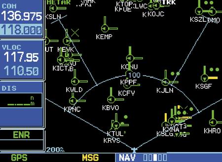
Intel 386-based Garmin 530 is displaying weather data (say, for
example, the uplinked graphical METAR page shown above),
something it wasn't originally designed to do, it still redraws
in perhaps a 1/2 second, depending on the selected range. Now, I
realize that I'm not comparing apples to apples, but my point
stands. If you build the thing to do one thing, then it better do
that one thing very well.
First,
the display updates take forever. For a box whose only job is to
process vector data and display it, they could have given it the
horsepower to redraw almost instantly. There was sometimes a 2-4
second delay between the time I hit a button and the time it
displayed the image, and I think that's too long. Even when the
Intel 386-based Garmin 530 is displaying weather data (say, for
example, the uplinked graphical METAR page shown above),
something it wasn't originally designed to do, it still redraws
in perhaps a 1/2 second, depending on the selected range. Now, I
realize that I'm not comparing apples to apples, but my point
stands. If you build the thing to do one thing, then it better do
that one thing very well.
Second, I noticed that the graphics were very accurately drawn in some cases, but very poorly drawn in others. For example, while the Garmin renders the rings of Class B or C airspace as true arcs at any range setting, the MX20 displayed the same airspace boundaries as straight lines drawn between multiple points about the arc, a characteristic that became evident to a far greater degree the more I zoomed in. I also noticed that the lines representing the airspace boundaries grew in size as the range decreased, which led to additional screen clutter. After I returned home, I pulled out a copy of the latest AOPA Pilot magazine and looked closely at the MX20 ad to determine if it showed this phenomenon. Strangely enough, it did. If you still don't know what I'm talking about, look closely at that ad, multiply the effects for ranges the average small single engine aircraft will use and you'll know what I mean. I also felt that the graphics were presented in colors that presented poor contrast as compared to other units I've seen, and I had to fiddle with the display options to get things to look better, but they never did seem quite right. To its credit, however, the display was readable, if not a bit washed out, in direct sunlight.
The unit is primarily controlled through a "soft key" interface. For those not familiar, this is the kind of interface that allows software to change the definition of the buttons based on the context of the display. Hardware engineers like this type of interface because, if implemented properly, it can reduce the number of buttons required, and therefore, perhaps, the complexity of the interface. The problem is if the software interface sucks, no number of soft keys will make the unit easy to use. The MX20 suffers from poor software design in this regard.
I found this particular soft-key interface confusing. Rather than changing the name of the button to indicate its function if touched at that point, the software changed the highlighting of the button in a counterintuitive (as well as cosmetically poor) manner. I found myself doing double-takes to figure out whether pressing a given button would enable or disable the function. Since I've been known to design an interface or two in the computer trade, I'm hard to please in this regard, but personal design preferences aside, I have to give this interface a C- in human factors design.
The final "nail in the coffin" was the fact that the LCD in this unit was defective -- it had many vertical lines of varying colors running through the display. While this could happen to any unit, Garmin or otherwise, it certainly didn't help promote the "wow" factor during the demonstration.
Ultimately, we decided against the MX20 due to price, performance, and the fact that we did not expect to keep the aircraft long enough to make it worth the investment. I guess we'll just have to watch out for 'dem 'dar hills the old-fashioned way. One thing is sure...$6200 will buy us a lot of extra fuel to use in the climb to cross those hills, that's for sure.
$16000, and no flightpath trend vectors?
Although we had no intention to buy it, one of the more
interesting toys we got to see that day was the Goodrich Skywatch
system, with data displayed on the Garmin 530. 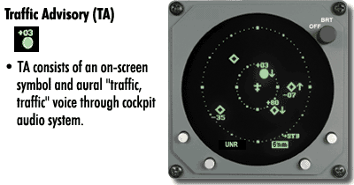 I have to admit it was pretty
neat to watch the diamond targets representing aircraft "fly"
around the screen at what I would call accurate range, azimuth,
and relative altitude.
I have to admit it was pretty
neat to watch the diamond targets representing aircraft "fly"
around the screen at what I would call accurate range, azimuth,
and relative altitude.
On the other hand, was it neat enough to justify $16K? I'd have to say "no". I realize it actively interrogates transponders, and therefore needs to undergo a certification process far more intensive than any passive unit, but I'm sure a smaller company with a lot less fat in middle management could sell a device like this for less. Sad, too. I think this technology should be in every suitable GA aircraft, and at a more reasonable price, it could be.
The single biggest peeve I have about the unit is that it doesn't provide flight path trend information. You can see the diamond target and its altitude. You can also see the vertical trend information. The unit will also call "TRAFFIC, TRAFFIC" over the audio system and display the word "TRAFFIC" on the lower right hand part of the Garmin display if it determines the traffic will conflict with your flight path, but there's no information on the display that indicates the direction the conflicting aircraft is traveling. Granted, if you closely watch several updates of the display you can get an idea, but when conflicting traffic is reported, just about the last thing you should be doing is looking *inside* the cockpit. This surprised me, especially when you consider that the new Garmin GTX330 *will* display trend information (or so I've been told) for about a 1/4 of the price.
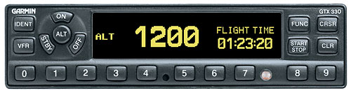
How about $4K for traffic with trend vectors?
The shop owner then told us that the new Garmin GTX330 Mode-S transponder supporting Traffic Information Service (TIS) was scheduled to start shipping to dealers across the country that very day, and they were slated to receive the first of 15 backordered units very soon.
 Based on my original goals for the
installation, obviously, traffic was a "perk", but the shop made
the 330 sound rather appealing for a mere $2200 over the GTX327
that I had originally considered to replace our aging KT76 for
reasons of reliability and ergonomics. I immediately asked
whether the 327 and 330 were, by some stroke of luck, pin
compatible, but learned they're not even tray-compatible.
Based on my original goals for the
installation, obviously, traffic was a "perk", but the shop made
the 330 sound rather appealing for a mere $2200 over the GTX327
that I had originally considered to replace our aging KT76 for
reasons of reliability and ergonomics. I immediately asked
whether the 327 and 330 were, by some stroke of luck, pin
compatible, but learned they're not even tray-compatible.
Unfortunately, no matter how sweet the latest gizmo to hit the street sounded, it wouldn't fit into the budget. I then suggested we go ahead with the 327, but my friend said that it would only be a year or so until the budget would allow a 330, so he suggested we keep the KT76 for now and upgrade directly to a 330 when the time came.
I then asked if we could do ANY prewiring for this without the tray and he suggested we prewire the serial data lines into the 430 so we wouldn't have to pull the 430 down the road. I ultimately agreed that would be the best route, because small screen or not, the 430 will give us Skywatch-like data at a reasonable price, even if we do have to wait a year or so to get it.
I'm not sure if we'll keep the KT76 in the panel long term, but we may just do that if we can spare the stack space of a second transponder. I'd question its use as a primary unit but I think it makes good sense to use it as a backup. And, even if it fails, we can easily replace it with a low cost Garmin GTX320.
And, for those that don't know, the 330 provides this information via the Mode-S datalink and relies upon ground equipment at approach facilities across the US. If you're outside the US or outside the coverage of an ASR, you won't get advisories. However, I don't think that's a big problem, since the approach facilities by definition cover the busiest airspace, and the "big sky" theory has a bit more merit outside of these areas.
Post-Sale Support
One of the last topics discussed was post-sale support, not only from the shop (which we already know to be outstanding) but from each of the avionics vendors we had considered. I'll avoid the details, but based on the discussion I'd have to say that Garmin support is better than UPSAT and Garmin generally supports their products longer than UPSAT. The shop reports that all major vendors provide acceptable support their systems for the duration of the warranty and generally try to do whatever they can to keep the customer happy.
Unfortunately, when it comes time to send a unit back to the
vendor out of warranty, there is usually a significant flat-rate
charge involved. Garmin charges $500 for the GNS series, for
example. And, unlike in years past, where you could go to a good
hardware tech to get your equipment repaired in the field for a
more reasonable rate, vendors today typically don't distribute
the information and resources necessary to fix their gear in the
field (they say it's due to field repair quality concerns...I say
it's to make more money), so your equipment is only worth
something for as long the manufacturer supports it. And, if you
don't understand the impact of this practice, re-read my treatise
on the Avionics Lifecycle, above).
To be continued...in 2003.
After the demo concluded, we went back to the office to discuss the installation and payment details, and scheduled the work for early next year. We asked them to order the equipment in advance of the price increases slated for the first of the year.
[Note: The job was completed in February 2003. Continue to part 2 for the follow up to this article.]