


New Jersey to Florida and Return
In early November 2001, I was given the opportunity to ferry a friend's C172 down to his vacation home in Titusville, Florida, and bring his C150 back to New Jersey for the winter. Here's a photo-essay of the trip.
Page 1 - Getting Started
The flight actually began several weeks prior to the planned departure date of November 8th, with coordination between myself, the owner of the airplanes I would be flying, a partner that would fly with me only on the trip down (largely due to payload limitations of the C150), and our friends at Flight Service, given the current state of the National Airspace System since September 11th.
I then started the planning phase and ordered all of the charts required for the trip (as well as a few not specifically required for our route, but necessary in case of a diversion). I used DUAT's new flight-planner to enter the route and get rough leg times using current wind data, just to get a benchmark on how far we could fly, which translated into how many fuel stops we would require. I later fine-tuned the route using the flight planner and settled on fuel stops at KPHF (Newport News, VA), KCRE (North Myrtle Beach, SC), and KCRG (Jacksonville, FL) enroute to our final destination of KTIX, Space Coast Regional airport in Titusville, FL.
At this stage, I made a decision to plan and file IFR for the entire trip, in spite of the fact that weather might be good VFR. I figured that our route was straight-enough under IFR that it wouldn't add significant time enroute, the fuel reserves for IFR were certainly comforting, and having our friendly air traffic controllers watch and guide us to our destination was a fringe benefit in unfamiliar airspace.
Amazingly, the weather cooperated for the most part and we pulled the airplane out of its hangar in NJ and took off for our first leg of the trip to Newport News, VA (KPHF) a bit after 8:30 AM. The first leg was uneventful (and since I had flown the route a million times, I neglected to take pictures...sorry) :-)
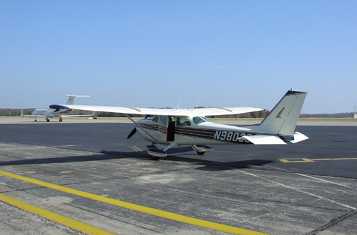 Here we are at
our first stop, Newport News, VA (KPHF).
Here we are at
our first stop, Newport News, VA (KPHF).
I used Rick Aviation based on the recommendation of the aircraft owner, since a friend of his makes regular trips to this area and finds it faster than going into Norfolk International (KORF). I'd have to agree.
The facilities at the largest FBO in Norfolk are a bit "higher class", but these guys were quick in turning us around, the fuel was cheaper here than in Norfolk, and speed on fuel stops was paramount.
As we were getting ready to leave, a LearJet with military markings passed by us on the taxiway, armed with air-to-air missiles and what looked like camera pods. A keen reminder of the times. Better stick to the flight plan route. :-)
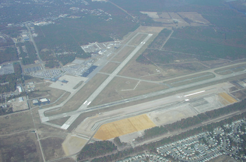 Here we are departing
KPHF heading southwest (paralleling runway 7/25) on our second
leg enroute to KCRE (Grand Strand Airport, North Myrtle Beach,
South Carolina. Rick Aviation, if you're wondering, is adjacent
to the black tarmac area on the far side of the airport to the
north of the tower.
Here we are departing
KPHF heading southwest (paralleling runway 7/25) on our second
leg enroute to KCRE (Grand Strand Airport, North Myrtle Beach,
South Carolina. Rick Aviation, if you're wondering, is adjacent
to the black tarmac area on the far side of the airport to the
north of the tower.
 We
filed for 6000 feet on the second leg from KPHF to KCRE, but
shortly after we reached 6000, faster traffic behind us on the
same route (a Baron, what else...) forced us up to 8000. Center
asked us if we wanted to descend back to 6000 feet after the
traffic passed but winds were actually slightly more favorable
at 8000, so we camped out there for the remainder of the trip
to KCRE.
We
filed for 6000 feet on the second leg from KPHF to KCRE, but
shortly after we reached 6000, faster traffic behind us on the
same route (a Baron, what else...) forced us up to 8000. Center
asked us if we wanted to descend back to 6000 feet after the
traffic passed but winds were actually slightly more favorable
at 8000, so we camped out there for the remainder of the trip
to KCRE.
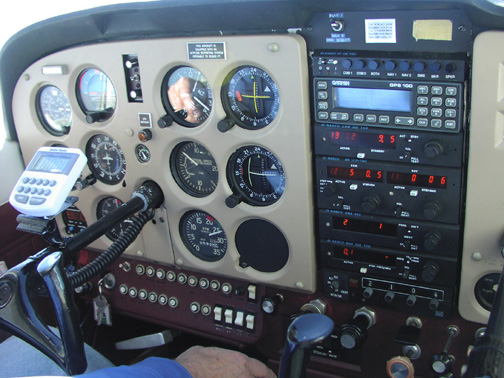
So here we are climbing through 7400 feet with the 180HP Lycoming w/ constant speed prop conversion giving us its best. Temps were ISA+6 that day, and this conversion has a tendency to run hot, so we had to increase climb speed and sacrifice a little climb rate.
And, no, the radios aren't having a fit. It's just my high shutter speed. It's bright up there! :-)
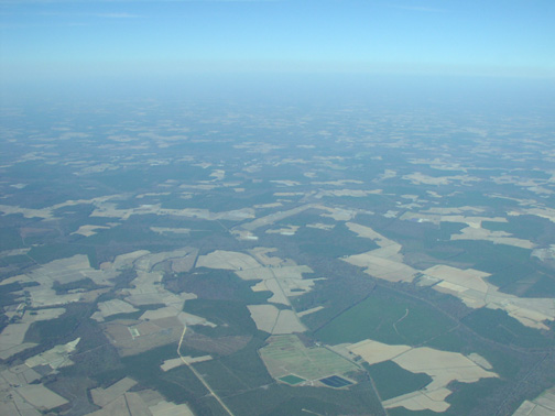 At 8000 feet over
northern North Carolina on the Victor 1 airway just south of
the Cofield VFR looking northwest. If you look closely in the
center of the picture, you can see the Tri-County airport (ASJ)
and its north-south facing runway about 10 miles away.
At 8000 feet over
northern North Carolina on the Victor 1 airway just south of
the Cofield VFR looking northwest. If you look closely in the
center of the picture, you can see the Tri-County airport (ASJ)
and its north-south facing runway about 10 miles away.
I took this picture after revising our planning for the remaining legs to KCRE.
For a few moments I disconnected from my piloting responsibilities and sampled the beautiful patchwork of this pale blue dot we call home.
It was also around this time that we started to notice the controllers talking with a funny accent (and, yes, I'm sure they enjoyed our New Jersey accents as well...even though I don't have one). :-)
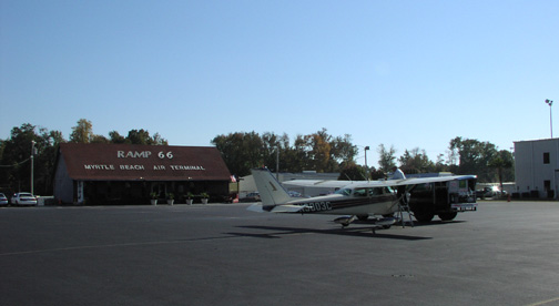 After arriving in Grand Strand Airport in North Myrtle Beach
South Carolina, we stopped at Ramp66 and found friendly folks
that would wind up helping me out BIG TIME on the way home.
After arriving in Grand Strand Airport in North Myrtle Beach
South Carolina, we stopped at Ramp66 and found friendly folks
that would wind up helping me out BIG TIME on the way home.
I highly recommend using these folks, particularly because they're open late (as I was to find out).
Fuel was pumping at a rate of $2.55/gallon, about average for the trip.
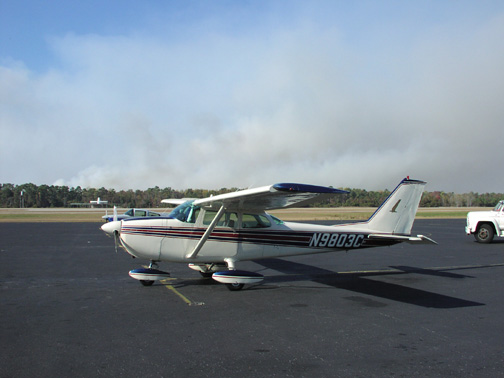 On
approach into Grand Strand, we ran into thick smoke from the
forest fires plaguing the dry mid-atlantic states, and were
forced to shoot a VOR-23 approach.
On
approach into Grand Strand, we ran into thick smoke from the
forest fires plaguing the dry mid-atlantic states, and were
forced to shoot a VOR-23 approach.
Visibility 15 miles north of the field (while on initial approach vectors) fell to about 4 miles, but then dramatically improved once we moved south and east toward the airport. At this particular time, the smoke was blowing to the north, avoiding the airport.
If you look closely, just to the left of our propeller, you'll see the Grand Strand VORTAC on the opposite side of the field.
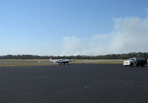 Here's another
perspective on the forest fires at KCRE, looking southwest.
Notice how dramatic an effect on the visibility the smoke has,
and how the wind definitely localizes the smoke. One or two
miles either way can make the difference between good VFR with
25 miles visibility and MVFR or IFR conditions.
Here's another
perspective on the forest fires at KCRE, looking southwest.
Notice how dramatic an effect on the visibility the smoke has,
and how the wind definitely localizes the smoke. One or two
miles either way can make the difference between good VFR with
25 miles visibility and MVFR or IFR conditions.
The moral? VFR flight is not recommended near forest fires. :-)
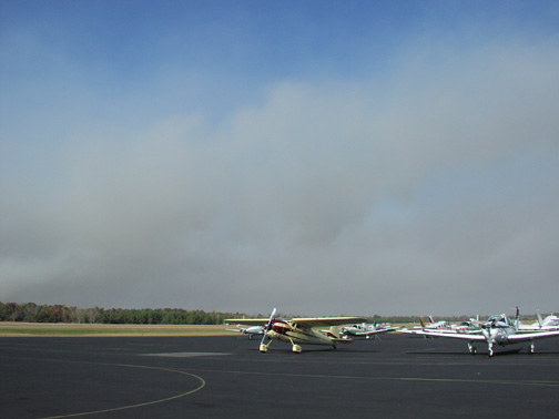 And yet another
perspective on the fires looking northwest...plus a nice
perspective on that beautifully restored Cessna 195!
And yet another
perspective on the fires looking northwest...plus a nice
perspective on that beautifully restored Cessna 195!