


New Jersey to Florida and Return
Page 2 - Grand Strand (KCRE) to Space Coast Regional (KTIX)
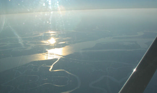
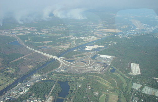 Here's a
neat shot looking north-northwest after departing Grand Strand,
which is located in the upper right corner of the picture.
Here's a
neat shot looking north-northwest after departing Grand Strand,
which is located in the upper right corner of the picture.
The Waccamaw River runs right through the picture and is considered by the local folk as a great natural firebreak. The people I spoke to who had homes on the east side of the river were only concerned about the smoke...which reduced visibilities to near zero at times since the fires flared up 3-4 days prior to my arrival.
On the way home, I stayed at a hotel only three miles south of the airport on the main road that parallels the Waccamaw River. While clearly visible at the time I took this picture, when I woke up the next morning, the scene was completely different. But, I'm getting ahead of myself... :-)
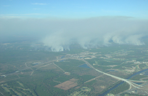 I snapped the last
picture for orientation with the airport, and snapped this one,
looking more to the west, to get a better sense of how the
smoke topped out at the inversion layer, in this case at about
8000 feet.
I snapped the last
picture for orientation with the airport, and snapped this one,
looking more to the west, to get a better sense of how the
smoke topped out at the inversion layer, in this case at about
8000 feet.
 Here we are about 6 miles north
of the Brunswick, Georgia VORTAC, southbound on the V3
airway.
Here we are about 6 miles north
of the Brunswick, Georgia VORTAC, southbound on the V3
airway.
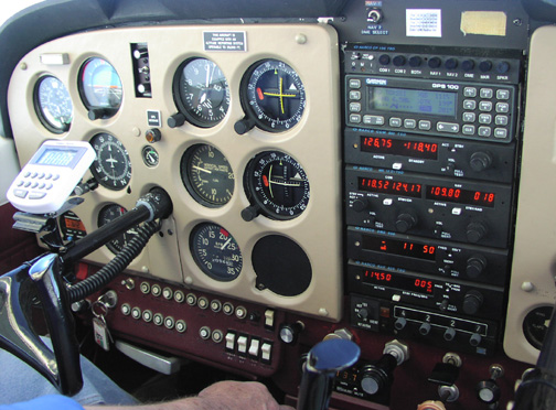
This is a decidedly better picture of the panel, level at 6000 feet in cruise at 23" of Manifold Pressure and 2300 RPM (about 75% power, maximum cruise).
Speed on this loonnnnng trip was clearly preferential to more efficient fuel burns (OPEC, you owe me!), so we put it to the wall and the Lycoming delivered a 118KT true airspeed. Unfortunately, due to unfavorable winds, we only managed to squeak out a 111KT groundspeed (take a close look at the upper right corner of the GPS display!)
And, if you'll notice, we're following the VORs as primary navigation, since this GPS was Garmin's first aviation GPS, manufactured long before anyone built an IFR-approved model. Not surprisingly, though, this VFR-only unit (particularly with Selective Availability disabled by the DOD) is far more accurate and consistent than the 1950's era VOR receivers...it just doesn't have the government's blessings for IFR flight. Your government at work. *sigh*.
A good shot of St. Andrews Sound, just south of the Brunswick, Georgia, VORTAC as sunset nears.
At this point, my flying partner and I started to discuss Sun angles, and the fact that not only could we expect warmer temperatures when we landed at our next fuel stop of Craig Field (KCRG) in Jacksonville, FL, but also expect sunset to be a bit later, too.
A long(er) day is always a blessing on long flights over unfamilar terrain, particularly because we knew that as long as the sun was up, we'd have a better chance to find a mechanic and/or fuel services at other airports, had we been required to make an unplanned stop.
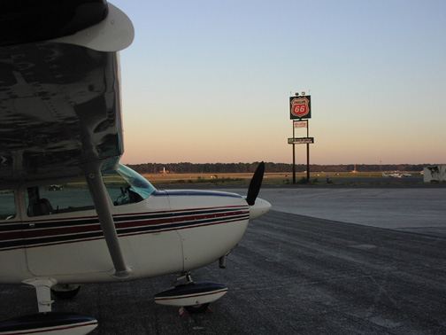 Ah, the
Sunshine State. We landed on runway 5 at KCRG and taxied to
Craig Air. This shot is looking east. If you look closely, you
can see the Craig VOR across the field, just in front of the
windshield.
Ah, the
Sunshine State. We landed on runway 5 at KCRG and taxied to
Craig Air. This shot is looking east. If you look closely, you
can see the Craig VOR across the field, just in front of the
windshield.
This is also a good shot of the Horton Short-Takeoff and Landing (STOL) kit, which amounts to nothing more than a cuff that is placed on the leading edge of the wing and (not visible here) some stall fences on the top of the wing.
The cuff has a smaller leading edge radius and is drooped slightly, helping to control separation at high angles of attack. This, in combination with the 180 HP Avcon conversion, definitely gives this machine outstanding takeoff and climb performance, but it has two undesired side effects: we take a 10+K hit in cruise speed, and the lower approach speeds required to get the aircraft on the runway translate into reduced elevator control authority in the flare. The result is usually very little flare and "mushing" onto the runway with the stick full aft. As a consequence, it is difficult to make an elegant landing on asphalt in this machine. The moral? This kit should come with a larger horizontal stabilizer/elevator.
 We departed KCRG at dusk for the
fourth and final leg of the day to our destination of Space
Coast Regional Airport (KTIX), Titusville, Florida.
We departed KCRG at dusk for the
fourth and final leg of the day to our destination of Space
Coast Regional Airport (KTIX), Titusville, Florida.
By the time I took this picture about 10 miles north of the Ormond Beach VORTAC southbound on the V51 airway at 4000 feet it was dark. Particularly disturbing was how absolutely dark and featureless the Atlantic Ocean appeared. I would occasionally look out the window and start to feel like I was in IMC at night. You definitely don't want to fly VFR over the ocean for that reason. Case in point...JFK Jr.
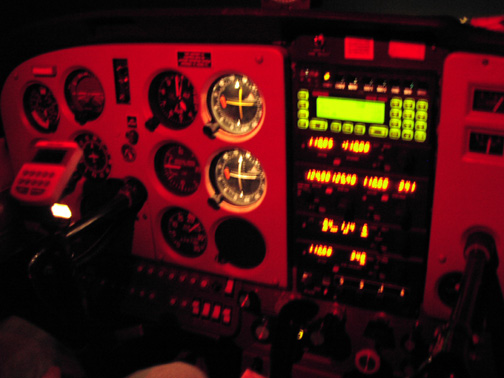
Not a great picture, but my first at night in an airplane with this camera. The shutter speed combined with very light turbulence at our cruising altitude resulted in a little blurring and overexposure of the image...but it was cool enough to see that I figured I'd post it.
Check out that great illumination of the Garmin GPS...those guys really got that right. I wish the newer units had the same kind of illumination (and the keypad method of waypoint entry for that matter...so much better than those F$#*@! knobs).