


Garmin 396 GPS Review
Page 2 of 2
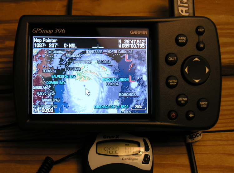
At home, the Garmin 396 provides weather and XM Radio via direct
or RF link
Interface Tour Continued
 Because the unit has
only one usb port, the XM receiver connects to the unit through
that port, and because the unit needs to be connected to a
computer to take a screenshot, pictures of anything involving
the XM receiver must be taken with a camera.
Because the unit has
only one usb port, the XM receiver connects to the unit through
that port, and because the unit needs to be connected to a
computer to take a screenshot, pictures of anything involving
the XM receiver must be taken with a camera.
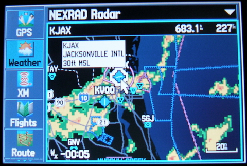
Here I've panned and zoomed to my sister's home town, Jacksonville, Florida, to take a peek at some nasty clusters of thunderstorms. My experience is that XM Weather NEXRAD processors remove most of the level 1 precip, so if you see green, you'll get light to moderate rain. Stay away from the yellow, orange, and (especially) red stuff.
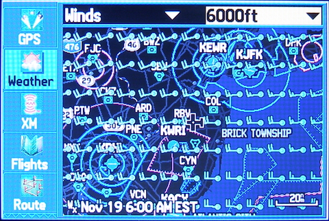 While
winds aloft forecasts change only every 12 hours and it's
possible to see these online (say, on ADDS) before you launch
and I rarely fly trips that are long enough or aircraft fast
enough to leverage picking one route or another for winds, it's
still helpful to see winds depicted on a map enroute.
While
winds aloft forecasts change only every 12 hours and it's
possible to see these online (say, on ADDS) before you launch
and I rarely fly trips that are long enough or aircraft fast
enough to leverage picking one route or another for winds, it's
still helpful to see winds depicted on a map enroute.
In this example, we're looking at winds at 6000 feet, which are forecasted to be west-southwest at around 20 knots. If you zoom out the barbs are replaced with streamlines so it's possible to get a nice "top-down" picture of what the pressure systems are doing.
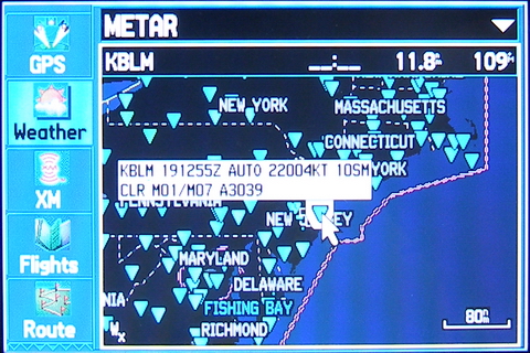 Near real-time
METARs and TAFs are one of the best features of XM Weather. If
you activate the cursor and hover over the reporting station,
you get a popup showing the undecoded weather. Since I grew up
reading undecoded weather, this is sufficient for me.
Near real-time
METARs and TAFs are one of the best features of XM Weather. If
you activate the cursor and hover over the reporting station,
you get a popup showing the undecoded weather. Since I grew up
reading undecoded weather, this is sufficient for me.
If you press ENTER while the station is highlighted, you get much more information.
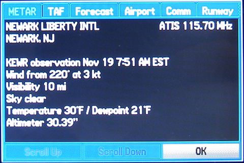 When you press
ENTER on the METAR you selected above, you get this METAR
detail display, with the METAR decoded to plain text.
When you press
ENTER on the METAR you selected above, you get this METAR
detail display, with the METAR decoded to plain text.
As you can see, the navigation tabs provide ready access to not only the METAR, but the associated TAF, long range forecasts, airport information, approaches.
Interestingly enough, if the airport doesn't have a TAF, it automatically picks the nearest TAF and displays it on that page, so you don't have to go searching for one.
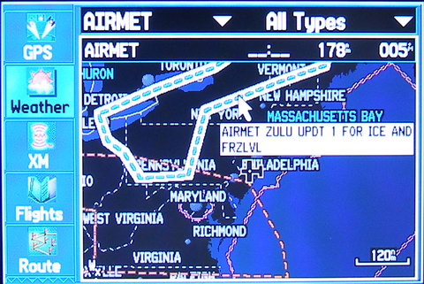 It's
November of 2005, and the low-level icing AIRMETs have returned
to the Northeast. This one covers the area downwind of the
lakes region, which was getting lots of lake-effect snow in
spite of the fact that the remainder of the Northeast was clear
and a million. What else is new?
It's
November of 2005, and the low-level icing AIRMETs have returned
to the Northeast. This one covers the area downwind of the
lakes region, which was getting lots of lake-effect snow in
spite of the fact that the remainder of the Northeast was clear
and a million. What else is new?
I think AIRMET/SIGMET depiction is probably second only to NEXRAD in terms of importance while flying because the average textual AIRMET/SIGMET description is completely indecipherable unless you know every coordinate used to define the perimeter of the advisory area. And even if you DO know the coordinates, I still say it's damn near impossible to precisely envision where "60 ESE YQB" really is.
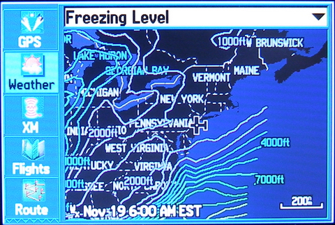 The freezing
level page is helpful in conditions where 100 miles in any
given direction may mean the difference between a cold ride in
the clouds and doing a bad impression of an ice cube.
The freezing
level page is helpful in conditions where 100 miles in any
given direction may mean the difference between a cold ride in
the clouds and doing a bad impression of an ice cube.
If it's not clear, the freezing level isotherms are colorized from a dark blue (low altitude) to a deep reddish/amber (high altitude). In this case, the Northeast is gripped by a cold airmass and the freezing level is at the surface. As you can see, we have to travel to southern Delaware before we see the freezing level rise to 1000 feet.
Although I don't usually fly at altitudes at which freezing temperatures are a concern during the summer, I found myself using this page to give jumpers an idea of how cold it will be at jump altitude, so it's not exactly worthless to low-altitude pilots during the hotter months of the year.
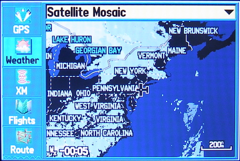 The
Satellite Mosaic page is another high-level overview page that
can give you a clear sense of where the clouds are (or perhaps
more importantly where they are not. If I somehow managed to
get stuck in the area covered by the icing airmet or had a
vacuum failure and needed to find the nearest cloudless sky,
this page would definitely come to the rescue.
The
Satellite Mosaic page is another high-level overview page that
can give you a clear sense of where the clouds are (or perhaps
more importantly where they are not. If I somehow managed to
get stuck in the area covered by the icing airmet or had a
vacuum failure and needed to find the nearest cloudless sky,
this page would definitely come to the rescue.
Naturally, it's possible to configure the zoom level at which the satellite mosaic will appear. Because at lower ranges (higher zoom levels) the mosaic essentially amounts to background clutter and covers the terrain map background I leave it off unless I'm viewing at the 80NM scale or higher.
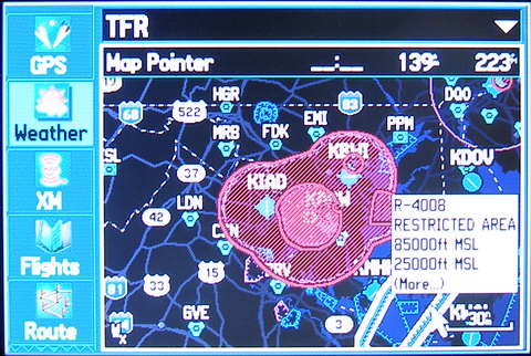 Here's a page I
wish we didn't need, but in this increasingly paranoid and
fascist regulatory environment it's nearly a necessity.
Here's a page I
wish we didn't need, but in this increasingly paranoid and
fascist regulatory environment it's nearly a necessity.
The blue hashed lines (highlighted in this case) represent traditional restricted airspace while the red hashed area represents the new plague upon aviation -- the so-called "temporary" flight restriction. For those pilots living under a rock the last few years, this particular "TFR" is threatening to become permanent.
Bottom line is if you want to rest assured that you are clear of TFRs in near-real-time as you fly, you need to fly with this kind of equipment. It's not cheap, but neither are aviation attorneys. And yes, it also shows stadium TFRs as well.
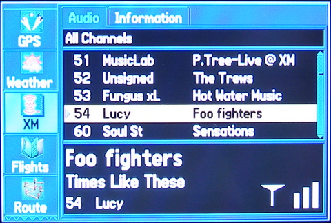 XM radio is handy at
home and in the airplane, but you need to be aware that you may
experience ground loop-induced hum in the audio if you connect
the unit to ship power and there is ANY difference in the
ground potential between the ground of your power outlet and
that of the audio panel.
XM radio is handy at
home and in the airplane, but you need to be aware that you may
experience ground loop-induced hum in the audio if you connect
the unit to ship power and there is ANY difference in the
ground potential between the ground of your power outlet and
that of the audio panel.
The hum in our 172 is so bad that I need to power the unit off of its internal battery if I want to listen to XM radio. Of course, the 396 is not at fault here...but I figured I'd mention it so you are not surprised. If you have this problem, call your avionics shop -- they can help resolve the issue.
Gripes
Well, I gave you the good news first, so I figured I'd leave the gripes until last. Much of this qualifies as nitpicking, but that's to be expected when a product like the 396 sets the bar so high. There's nothing left to gripe about except the small stuff! To that end...
Proprietary Memory Stick
With the ready availability of PC industry standard flash memory card formats like CF, SD, and XD, I find it disturbing Garmin chose to utilize a proprietary design.
The flash card that came with the free auto kit was only 128MB, and that allows me to load road maps for New Jersey, extreme eastern Pennsylvania, and extreme southeastern New York and NYC.With 2GB flash cards available today, I could put the entire US on a card...but no, I have to buy what Garmin provides and pay Garmin's ransom. Then when I travel to other cites I have to remember to drag my laptop out and reprogram the GPS with the maps I need for that location. That is SO 1990s. I wish Garmin would get with the program!
Lack of Full Approaches
The Garmin 396's database and software allow one to fly the final approach path of any instrument approach (as supplementary navigation, of course). There is even a "vectors to final" option much like that on my IFR approved GNS430. However, they purposefully excluded all waypoints and holding patterns associated with the approach transitions or missed approach procedures because they apparently fear pilots using it as primary navigation on instrument approaches.
It makes no sense to intentionally cripple the unit when I am already required to have an IFR approved GPS on board the aircraft. If people fly approaches with primary reference to the Garmin 396 they are breaking rules. It is by definition for supplementary navigation only. Why not just fully equip the unit and leave it up to the pilot to decide what features to use?
Stupid Attorney Warnings
Let's face it. Every pilot knows that the next time they step in an airplane it may very well be their last time. We don't need to be reminded of it -- particularly every time we select some feature on a system we know full well may play a part in our demise. If Garmin wants us to acknowledge that attorneys have too much power in this country, at least make it something we acknowledge ONCE, preferably during the startup sequence. Better yet, store the acknowledgement somewhere in non-volatile memory so I can accept it once and be done with it. It's stupid things like this that remind me of that old joke -- what do you call 5000 attorneys jumping off a cliff? A start.
Inability to Take "Live" Screenshots
I often find glitches in databases or just an interesting depiction on the display (like weather) while I'm flying. I'd like to be able to press a certain key combination and take a snapshot which is stored on the memory card for later extraction.
The current method required to acquire screenshots requires the unit be connected to a PC, a process which uses the unit's only USB port. This means I can't have the XM receiver connected at the same time, so I want to take weather-related pictures I have to use a camera, and my camera doesn't bring out the same clarity and color as the real display.
Arc Mode Navigation Display Lacks CDI Depiction
While the arc mode navigation display is a brilliant piece of engineering in that it displays a lot of information clearly, what's missing is a simple course deviation indicator display.
I'd like to have a display (similar to the VNAV indication that overlays the arc mode display in both upper corners) that shows me where I am in relation to my course. Showing the actual number of miles next to the display would help too.
While it's possible to select a split screen and show the HSI for this information, that robs too much screen real-estate for my liking.
XM Antenna is Magnetized
While I can certainly see the value in a magnetized antenna in automotive use, magnets and an aircraft's standby compass don't play well together. I know that the magnets can be permanently removed (theoretically without voiding the warranty...but don't quote me on that) but that's no solution if you want to use the antenna while driving too. I sure wish Garmin could have integrated some kind of removable magnet solution for this antenna. A simple quarter turn locking mechnism would work for me.
Conclusion
What else can I say? As you can see from this brief overview, the Garmin 396 is a powerful addition to the cockpit and well deserving of your hard-earned dollars, particularly if you fly when the weather isn't cooperative. It's outstanding XM receiver integration and perfect display make this unit the standard by which other solutions will be judged.
[Note: The 396 is ancient history now but it can be found for a reasonable value in the used market and I still recommend it if you can't find a 496 or later model within your budget]