


Sunrise In Florida, Sunset In New Jersey
An invitation to my sister's wedding in
Jacksonville, Florida affords an
opportunity to exploit the fun, freedom, and luxury in travel by
General Aviation
Page 2 of 3
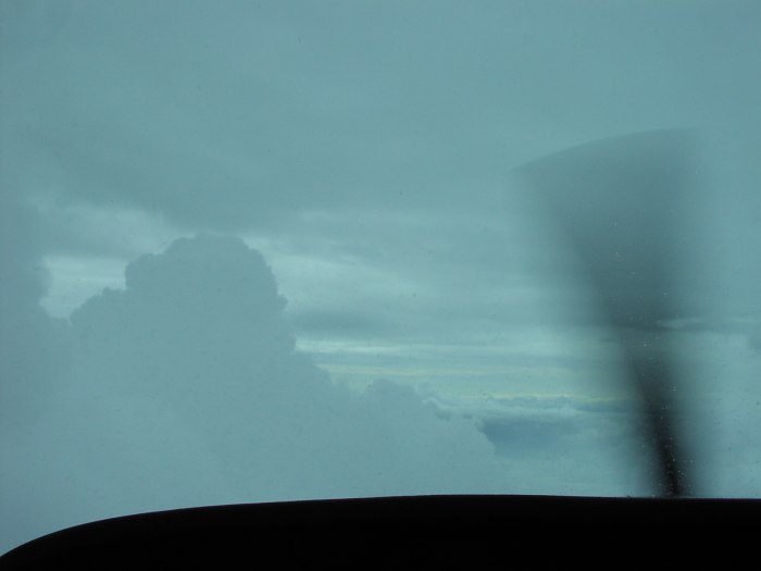
Emerging from a gap between thunderstorm cells north of Savannah,
GA
Ramp 66
Again, courtesy of the entertainment system, it felt like a bit over an hour (when in fact, another 2+25 had passed) by the time I was cleared to land at Grand Strand. As I taxied off the runway, I didn't recognize the place. I kept looking for the familiar brown "Ramp 66" roofline, but it soon became apparent it had been replaced by a large white hangar, complete with putting green out front -- now THAT's the way to appeal to the golf-loving pilot (or is that the piloting-loving golfer?). :-)
Along with the new exterior, I found the interior fully redesigned to provide a large lobby / passenger waiting area, pilot lounge with really comfy chairs, conference room, kitchen/cafeteria, and, (thankfully for this Florida-bound pilot today), a nice pilot weather briefing room with Meteorlogix weather terminal supporting near-real-time NEXRAD Radar imagery. Not even a hint of a grungy, cold airline terminal with thoroughly uncomfortable hard plastic seats anywhere.
 Contrary
to my usual practice of filing flight plans ahead of time, I
decided to file each plan on the fly today. Good thing, too. When
I planned the trip the prior night, I had originally expected to
fly non-stop from Grand Strand to Jacksonville. At 2+45, it was
at the absolute maximum of the airplane's IFR range with
reserves, but increasing southerly winds, combined with an
uncertain weather picture south of Hilton Head, warranted filing
a single plan to Hilton Head for 1+20 to serve as a fuel stop and
last minute check of the weather.
Contrary
to my usual practice of filing flight plans ahead of time, I
decided to file each plan on the fly today. Good thing, too. When
I planned the trip the prior night, I had originally expected to
fly non-stop from Grand Strand to Jacksonville. At 2+45, it was
at the absolute maximum of the airplane's IFR range with
reserves, but increasing southerly winds, combined with an
uncertain weather picture south of Hilton Head, warranted filing
a single plan to Hilton Head for 1+20 to serve as a fuel stop and
last minute check of the weather.
After the FSS briefer accepted the plan, he confirmed that there were some areas of rain and possible convective activity forming to the west and south of Savannah, but that the route from Grand Strand to Hilton Head looked clear. He also mentioned another strong line of storms out in western Florida ahead of the cold front that were expected to reach the east coast the following morning.
Aside from some lower scattered decks from 2000-7000, I could expect a reasonably comfortable flight. After settling the fuel bill and doing the requisite preflight checks and aircraft paperwork, I launched for the relatively short hop to the beautiful island of Hilton Head.
Bumpiness Before the Storms
In spite of being at 7000 feet for the leg to Hilton Head, I found that the cloud layers were now topping out above my altitude, so I had to ask Charleston Approach for several minor deviations. After the second deviation request, the controller cleared me to "deviate as necessary, proceed direct to Hilton Head airport when able". I considered that music to my ears, as it allowed me to have a bit of fun with the buildups, treating each one as a pylon in a giant slalom course, banking up to 30 degrees around each one in order to keep myself in clear air and out of the light to occasionally moderate turbulence inside them. Considering I'd just flown two long legs, at 1+20, this leg seemed almost "too short". Before long, it was time to begin a descent for Hilton Head.
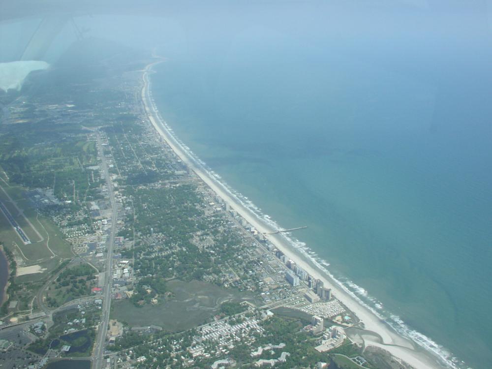
The one significant difference between this arrival and the last time I visited HXD was a part-time control tower. If you ever read the travelogue of my first ferry flight to Florida, you may recall my comment about the incredible mix of traffic on Hilton Head. Large corporate jets shared the pattern with Cessnas, and the result was about as confusing and delay-inducing as you might think...and that was during good VFR conditions. As a non-towered field, IFR operations were limited to one-in / one-out, so during less than ideal conditions, significant delays could be incurred by everyone trying to use the airport. Thankfully, however, someone got the message and decided that Hilton Head's traffic rates and mix warranted a tower, albeit a seasonal and part-time one -- so for the first time landing at Hilton Head, I was greeted by a friendly tower controller.
 Gotta Love NEXRAD!
After I asked the attentive line crew for a top-off, I made a line for the weather room to look at what awaited me on my last leg of the day. Given that the weather had generally deteriorated on approach to Hilton Head, I wasn't particularly surprised at what I found. The original route took me along the coast, via Savannah, Brunswick and Craig VORs along V37, but radar indicated that route was out of the question. A line of storms had formed directly over and slightly to the west of the route. While the upper level steering winds (30K-40K feet) were quite strong from the west, the storms weren't moving that quickly, likely due to the relatively strong low-level winds from the southeast.
Of course, this wasn't supposed to be happening. Both my sister and a Gainsville AFSS weather briefer I contacted yesterday for a "local" interpretation of Florida weather had told me that although the typical summer pattern of afternoon storms hadn't yet arrived (being late April, after all), when the pattern DOES form it works like this...
Storms form during the peak heating of the day (2-3PM) over land, because the land heats up faster than the ocean, generating a sea breeze. This has the effect of keeping the storms inland, perhaps only 15 miles from the coast. Then, as the afternoon turns into evening, the situation reverses, as the land cools more rapidly than the water, and a "land breeze" push the storms offshore. The problem in my case was that I was arriving at the absolute worst time -- 4-6PM, when the storms are in the process of moving offshore. What to do? Wait a bit. Possibly get a room for the night -- anything but try to fly that route into that stuff.
If there is one good thing about thunderstorms, however, it's that they can dissipate about as quickly as they form, and I was betting that by the time my tanks were topped off, I called my sister to let her know where I was, returned the 5 voice mail messages I had waiting on my phone, and finished cleaning the windows, the weather picture would change for the better. To make a long story short, it didn't change for the better initially, so I grabbed a seat in front of the TV for a half-hour, then went back in to the weather room to closely study the radar imagery loop for about 5 minutes. I caught a hint of a hole opening up in the northern section of the line north of Savannah, and returns around Savannah indicated mostly green with a few hints of yellow (level 1/2 precip), rather than the widespread deep shades of yellow and red associated with convective activity. Since NexRad is conservative when it comes to displaying rainfall rates, I knew the real world didn't look as bad as the picture. That was the good news.
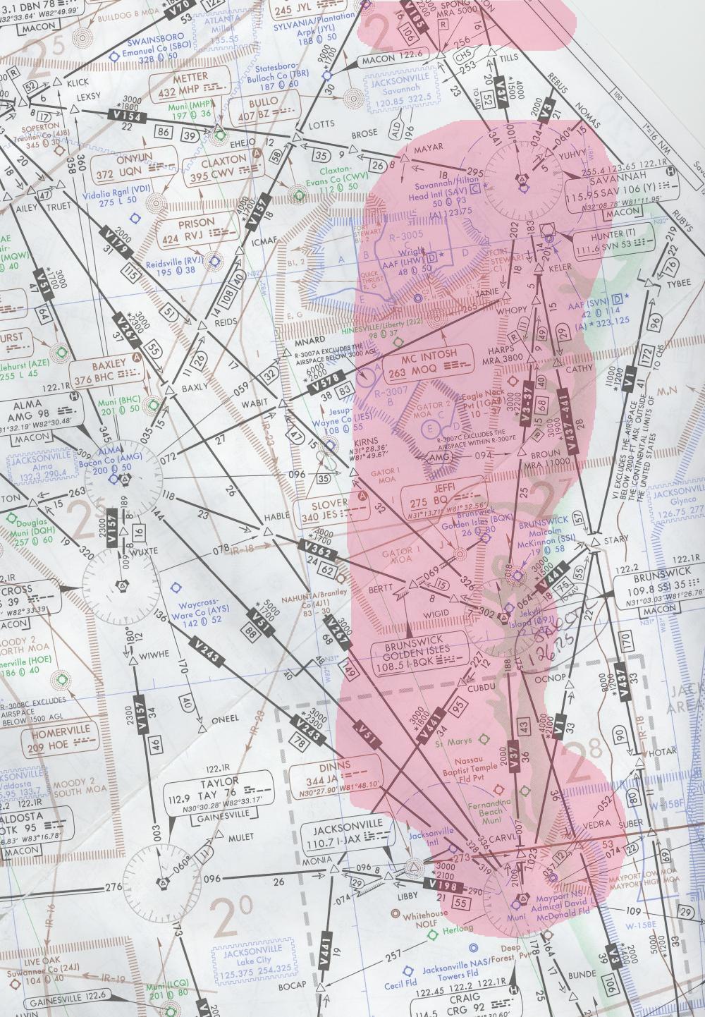
The bad news is that it appeared like a cluster of cells south of Savannah were growing, and moving more toward the northeast than east - directly toward Hilton Head.. This meant I couldn't hang around Hilton Head until late this evening, when the chance for thunderstorms in the Brunswick and Jacksonville areas was to be removed from the forecast, because these storms would very likely hang just offshore and trap me there. Armed with experience reading NexRad radar imagery and a bit of intuition, I made a decision to file a route (LOTTS V157 TAY V198 CRG) to punch through the line at its weakest point, and fly around the back edge of the storms, betting that by the time I got down to Craig, the storms would have moved out of the area. In the remarks section I put the text "ROUTE REQUEST FOR WX AVOID", and hoped that they'd get the picture and give me the filed route.
 Plan with my name
on it...
Plan with my name
on it...
After startup, I called ground with my tail number as usual, and the ground controller (same as the tower controller, actually) came back and said "Cessna 9803C, I have a flight plan to Jacksonville Craig with your name on it, ready to copy?" I responded and he came back with precisely the route I'd filed, and that was a good thing. Looking out the window during taxi confirmed that the only direction toward the south I'd go was exactly where I'd filed. The clouds were noticeably lighter in that direction, and for some reason I couldn't help but think of that lady from Poltergeist saying "go into the liiiiiiight...." Creepy thought, I know, but that's the kind of crazy stuff that can go through one's mind when trying to outsmart the awesome forces of nature.
I soon launched and departure gave me a heading slightly to the right of the direct course to LOTTS. When I asked what the vector was for, he said "climb", but after I penetrated the first few layers of clouds obscuring what lay beyond, I understood what the vector was really for -- to stay north of a smaller buildup and some precipitation (you see, controllers aren't supposed to give vectors for weather, and some avoid the liability by avoiding direct reference to it...but I digress).
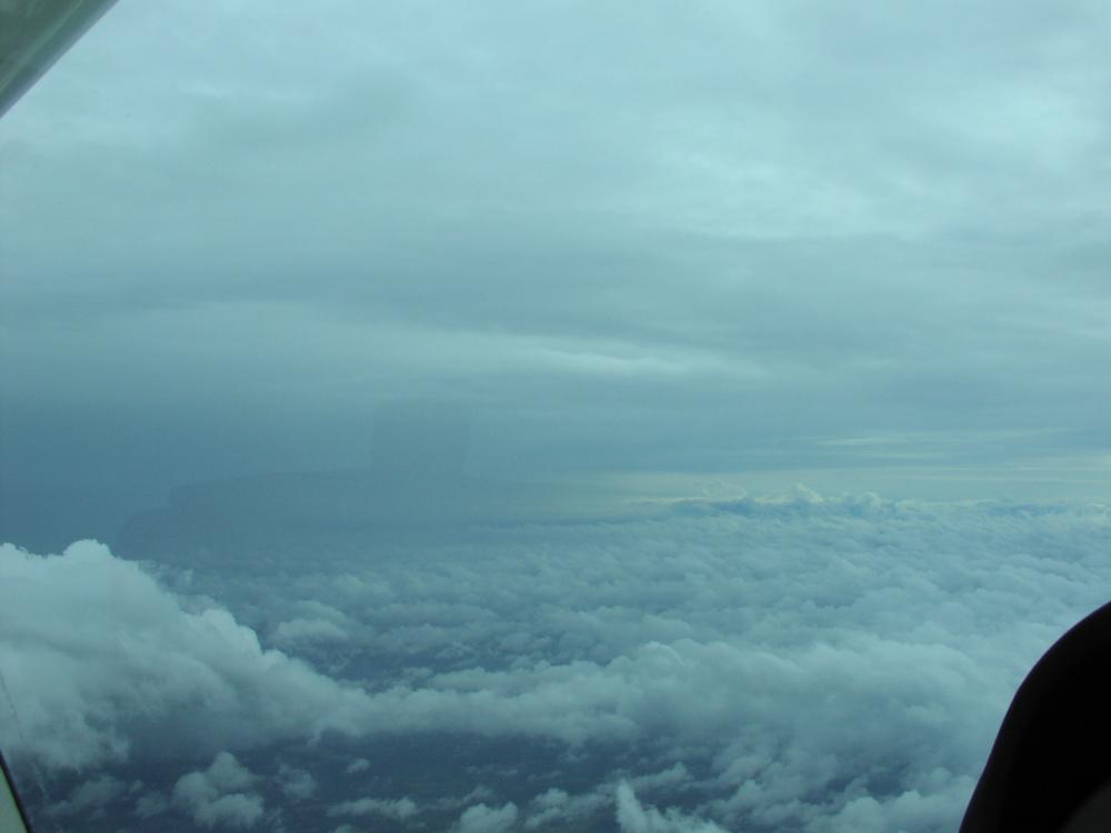
After I passed the cell, I asked for and received clearance direct LOTTS. Within a few miles I emerged from the bulk of the obscuring clouds to find myself on the other side of the weather, and I couldn't help but let out a short proclaimation of victory. "YEA!". In the words of the late George Peppard (ahem...Hannibal Smith)..."I love it when a plan comes together!" And, believe it or not, I encountered only level 1 -- occasionally level 2 -- precipitation, and light turbulence penetrating the line. It's definitely true what they say...NEXRAD makes things look worse than they really are (which I suppose is better than the other way around).
The picture was taken after I'd exited the line and is looking south, about 5 miles east of LOTTS. The controller earlier offered a turn direct to Taylor VOR, but that would have put me too close to the back edge of the cells, so I decided to fly to LOTTS, then down V157 a bit. Just north of Alma VOR, the storms had moved sufficiently east that I felt comfortable doing direct to the outer fix for the RNAV 14 approach. Jacksonville approach did a great job stepping me down so all I had to do was maintain a standard rate descent from 7000 to the 3000 foot initial altitude for the approach. I was somewhat concerned about the approach only because the ATIS reported a 600 scattered deck, which is 200 feet below the MDA for the approach, but by the time I was past the final approach fix and got below a higher cloud deck the runway came into sight and I proceeded to execute a smooth landing. Mission accomplished!
Welcome to Craig Air
I think the best thing about General Aviation is that even though I'm flying a simple 4-seat single engine airplane, I get what I consider "Jet Set" treatment when I travel. No waiting in long lines for ticketing, boarding, or baggage claim. I can also take anything I want along with me, too, including guns, nail clippers, paper clips, and other potentially lethal weapons. :-)
After taxiing up to Craig Air, the lineman directed me to park in front of the facility within 20 feet of the gate that would provide me access to my rental car, which was ready and waiting beyond. Naturally, I requested the car in advance, and told them of my estimated arrival time, so this wasn't magic, but when was the last time you could fly via the airlines, get off the plane, walk 30 feet, and turn the key on your car?
I had also requested hangar space for the airplane, as cheap insurance against possible thunderstorm-induced wind or hail damage, so I locked the airplane with the parking brake off so the line crew could later tug it into a nice corporate hangar sized to fit a medium jet. In no time I was on my way to a nice hotel recommended by my sister, and the airplane was relaxing in high style as well. :-) And THAT is the way to arrive.
Good Eats
I tend not to eat much when I travel, but I couldn't turn down a home-cooked meal prepared by my big sis. Starting off with a LARGE salad of fresh greens, I barely had enough room to fit a generous helping of kale, broccoli and carrots, and other great food to top off a long day of flying.
Later Saturday, the family was treated to a great dinner at a local European restaurant right across the street from my sister's house in Jacksonville Beach. Complete with award-winning chefs and a waitress with a captivating German accent, this place had both quality food and great atmosphere. Our large group was the first to arrive that evening, so the place was empty when we got there, but I was surprised to look up after some engrossing conversation with our new family members-to-be that nearly every seat was filled. Apparently the word is out about this place.
After perusing the menu trying to narrow down my choice from a handful of finalists, I decided on the Sauerbraten with a side of delightfully-prepared Spetzel and red cabbage. mmm...mmm...MMMMMM! Of course, beers and wines were flowing heartily as well, and I was enjoying discussions of everything from home towns to (yup, you guessed it), flying. I just didn't want to leave the place, but in a few all-too-short hours we did exactly that so everyone could get to sleep early for tomorrow's festivities.
Here Comes The Bride
It's 4AM. Do you know where your synapses are? At this point on Sunday morning, mine were shorting out, still drowning in that great German brew, but it was time for me to get up in preparation for the ceremony. A bit early you say? Not for a sunrise ceremony on the beach!
Before I knew it, there I was on the beach sitting in a chair, one of several my brother and I'd nestled into the sand for ourselves and our guests. I couldn't remember the last time I was on a beach, to say nothing of a beach in Florida...at Sunrise, and, to top it all off, wearing a suit, but here I was. Preparations complete. I found myself silently looking out into a dark ocean with a hint of light on the horizon to the east, listening to the almost invisible waves crash on the shore near high tide. My blood pressure sank to a number I'd not felt in 10 years. As far as I could tell, I had no job. No responsibilities. No one to see. No place to be. I could get to enjoy this.
As I turned my head slowly to look around -- and above -- sadly, I saw nothing but low clouds and fog, obvious remnants of the storms that passed through last evening, saturating the lower levels of the atmosphere. My sister had obviously planned this to be picturesque, but it didn't look that way at the moment. While my brother went back to my sister's place to get the bride-to-be, I took some time to close my eyes and absorb the sights and sounds of a beach waiting to be greeted by the sun of another day.
Then a strange thing happened. I opened my eyes after but a few minutes when I heard some commotion associated with the bride's arrival, and I looked up to find a widening hole in the clouds. I kid you not. It really was this sudden. Before long, the hole stretched from a point just over us, across the ocean to the point of the rising sun. It was still foggy and nasty in every other direction, but it appeared as though we might get that beautiful sunrise my sister had wished for after all.
The ceremony began as my sister began walking the small bridge that led onto the beach, and after everyone was positioned, several poems were recited before the couple took their vows. The ceremony was to end by the couple's symbolic walk toward the ocean for some pictures. By the time they started walking, the skies above us had largely cleared and the sun made its appearance, as scheduled, just above a cloud deck along the horizon. It was a real hallmark moment, a perfect end to all of the planning that got us to this point, and -- of course -- a perfect beginning to the couple's lives as husband and wife.
 Choices,
Choices
Choices,
Choices
After the ceremony, I had the opportunity to check weather for the trip home. As late as 7AM (hey, I got up at 4AM, remember), I was still undecided as to whether I'd fly home later today or Monday.
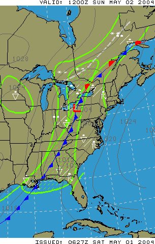
The synopsis revealed a familiar pattern -- a slow-moving cold front stretching across the eastern third of the nation with rain showers and thunderstorms forming ahead of the front. Until the peak heating of the day, most of the storms were forecast to be of the hit or miss variety, forming mostly in clusters, but I'd been watching the situation long enough to know that there was a distinct chance that strong, impenetrable lines of thunderstorms would form about 150 miles ahead of the front.
The forecasts showed the greatest chance for thunderstorms along the southern portion of the route, so if I was going to depart today, I knew I had to do it early enough, or I'd get caught in the mess at some point along my trip up the coast.
Normally, I'd avoid flying in an area of forecasted convective weather, but Mother Nature was dangling a carrot in front of me: forecast 40 knot tailwinds at 6000 feet and 50 knot(!) winds at 9000. Those winds would surely push the 115 knot Skyhawk home in record time, and, I reasoned, reduce my exposure to any weather, including strong surface winds averaging 15 knots with gusts to 25 knots.
I also considered the fact that while the storms were forming ahead of the front, and the forecasts were for reasonable (if not clear) weather Monday, the prog charts were showing the front directly overhead my route Monday morning, and I had a feeling that even if the risk for convective weather slid off the coast, an extensive area of low clouds and precipitation was practically guaranteed. Again, the TAFs weren't showing this...it was just a gut instinct.
Although I had to cut my time short with my family, after weighing my options, I decided to launch as soon as I could check out of the hotel and get to the airplane. Fortunately, my family was understanding, and wished me well on the trip. The next task was getting an official briefing and filing the first leg back, which, thanks to the favorable winds, would overfly Hilton Head enroute to Grand Strand.