


Sunrise In Florida, Sunset In New Jersey
An invitation to my sister's wedding in
Jacksonville, Florida affords an
opportunity to exploit the fun, freedom, and luxury in travel by
General Aviation
Page 3 of 3
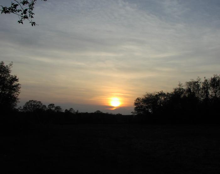
Sunset in New Jersey, May 2, 2004
(with thunderstorms visible on the horizon)
"Tower reports heavy rain at the field"
When I arrived at Craig field, Craig Air had the Skyhawk waiting out front, and I used a baggage cart to quickly load the airplane while trying not to go deaf from a nearby dog whistle (er, Lear 35) spooling up. At approximately 9:45, I received a call from the tower, "On departure, climb and maintain 3000, cleared for takeoff". At about 1000 feet I entered the clouds, and continued my climb to 3000, until Jacksonville Departure gave me a vector to intercept V37 south of Brunswick, VOR and a clearance to climb to 7000 feet.
Upon reaching cruising altitude I realized that I would not be able to get on top of the clouds, and would need to rely a bit more on ATC for weather avoidance than I'd wanted. As Jax approach turned me over to center, I overheard the controller mention a convective sigmet that had been issued for an area just south and to the west of Savannah. A quick call to flight service revealed that the area of weather was just to the west of V37, near Wright Army Air Field, and it was moving to the northeast at 35 knots. This meant that while it wasn't over my planned route right now, it would be by the time I got there. A deviation was in order.
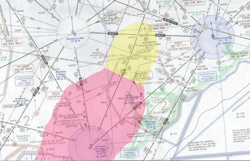
I looked at the chart, and an old friend popped into view -- LOTTS intersection. From there, I drew a route up V157 to Allendale, then to Vance VOR, direct KIMMY intersection on V1, direct Grand Strand. Jacksonville Center turned me over to Savannah Approach at that point, and I made the request with him.
"Savannah Approach, Skyhawk 9803C, Level 7000, Request".
"Skyhawk 9803C, Savannah, Altimeter 29.99, say request".
"Yes, sir, 03C requires a deviation for weather. We'd like to fly direct LOTTS, V157 Vance direct KIMMY V1 direct destination".
"Skyhawk 03C, I have your request."
(30 seconds pass)
"Skyhawk 03C, Savannah -- cleared direct LOTTS, V157 Allendale, V417 Charleston, rest of route unchanged. The area of weather associated with the Convective Sigmet is nearly on top of Savannah right now, and that should be no factor for this route. Be advised that there appear to be cells forming to the north of Savannah, though V417 looks clear at the moment. Fly the route, and if you need another deviation as you get up near Allendale, we can work that out."
"Ok, direct LOTTS, V157 Allendale, V417 Charleston, rest of route unchanged, 03C, thanks for the help".
 As
I made the necessary changes to the Garmin's active flight plan,
I overheard the controller working someone coming in from the
north along the coast into Savannah International. As I was
occupied with other tasks, I don't recall the call sign or type,
but I certainly perked up when the controller said to this pilot
"Be advised, sir, tower reports heavy rain at the field". I don't
know what happened to the guy (sounded like was turned over to
tower for landing), but that's news you don't want to hear on
final approach!
As
I made the necessary changes to the Garmin's active flight plan,
I overheard the controller working someone coming in from the
north along the coast into Savannah International. As I was
occupied with other tasks, I don't recall the call sign or type,
but I certainly perked up when the controller said to this pilot
"Be advised, sir, tower reports heavy rain at the field". I don't
know what happened to the guy (sounded like was turned over to
tower for landing), but that's news you don't want to hear on
final approach!
I wonder what the weather has in STOAS for me
The deviation plan worked pretty well. Around Allendale, I got my first few peaks of Sun and breaks in the clouds sufficient to allow me to view the route ahead along V417. The darkness to the southeast was unmistakable, but things looked much better in the direction of Charleston. Ah, that's good news.
Savannah Approach turned me over the Charleston Approach at this point, and the friendly controller offered a report of some level 2 activity over the STOAS intersection. Level 2 could mean simple rain showers, or the start of a nice buildup, but I wouldn't know until I got there....or would I?
"Skyhawk 03C, I have a regional Jet just about to pass through the area I pointed out. I'll get a ride report from him and let you know what he finds."
"Thanks much, sir!, 03C."
(a few minutes pass, during which I hear the ride report, and the controller confirms it)
"Skyhawk 03C, as you probably heard, looks like some very light turbulence and only some light rain in that area beginning about 10 miles ahead of you. Still appears to be level 2."
"Good news, sir, thanks for the help, 03C."
 You
wanna play, you gotta pay
You
wanna play, you gotta pay
Before long, I'd passed through the area of light rain, and Charleston Approach cleared me direct to Grand Strand. I had expected to fly an approach, because I was mostly IMC for a good portion of the route, but the ATIS was reporting 2300 scattered and 7 miles, so I changed gears and requested the visual. I got within 10 miles and broke out of the clouds to find the strong southeast winds pushing most of the clouds inland. It was a pretty amazing sight...within five miles of the coast, the weather was good VFR, but farther inland the clouds were hanging on in earnest -- gradually sloping upward like a mountain range.
Naturally, I'd just enjoyed a relatively short flight thanks to strong southwest winds aloft, but I was about to pay a small price for that gift upon landing. Winds were averaging 12 knots gusting to 18 knots when I landed at Grand Strand, and while that doesn't seem like much, the low level wind shear was more "exciting" than I'd experienced in recent memory. But, as they say, if you want to play, you gotta pay.
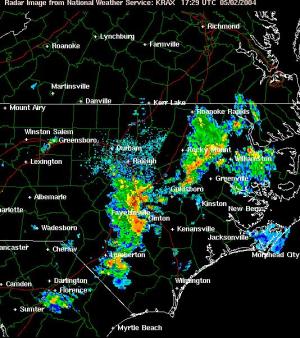
I was eager to get moving on my second leg, so after my landing(s!) I made a line for the weather console. The picture wasn't particularly favorable. In the relatively short 2+20 since my departure from Jacksonville, several clusters had formed in South Carolina and North Carolina, in particular. Most of the activity seemed to shut down at the NC / Virginia border, but it quickly became apparent that I'd have to scrap plans to Newport News. There was a coastal route available, but my instinct told me to stay on the backside of the storms, if possible. The last thing I wanted to do was get trapped on the front side of the storms and deal with the limited options provided by the route due to extensive areas of restricted airspace, a limited number of alternate (civilian) airports, and that little puddle they call the Atlantic Ocean.
 I looked at the radar
imagery more closely and saw an opening between some clusters
forming just to the south of Florence, and a far more extensive
area covering a good part of NC up toward Fayetteville. At the
time, Fayetteville was covered with strong returns, so I
initially thought I'd take a more southerly route via Florence
(or maybe just file there and get a deviation enroute to an
intersection slightly to the north). However, flight service
interpreted Florence as a "no-go" at this time because in the 30
minutes it would take me to depart and get there, the cells would
be directly overhead.
I looked at the radar
imagery more closely and saw an opening between some clusters
forming just to the south of Florence, and a far more extensive
area covering a good part of NC up toward Fayetteville. At the
time, Fayetteville was covered with strong returns, so I
initially thought I'd take a more southerly route via Florence
(or maybe just file there and get a deviation enroute to an
intersection slightly to the north). However, flight service
interpreted Florence as a "no-go" at this time because in the 30
minutes it would take me to depart and get there, the cells would
be directly overhead.
Just before I called flight service, another pilot appeared in the briefing room. It turned out that he was headed to Allentown, PA, about 50 miles west of my home base, so we ultimately decided to fly the same route. We both choose Richmond as a good stopping point and filed our flight plans. I wished him good luck and took a couple extra minutes to grab a snack.
Fast Forward
Shortly after starting up, I overheard the pilot pick up his clearance. I took mental note of his tail number, and soon picked up my clearance as well, which matched his: Grand Strand V136 Raleigh Durham V155 Lawrenceville V157 Richmond. I managed to launch only about 10 minutes behind him, and given our comparable true airspeeds, it quickly occurred to me that he'd be a valuable real-time source of weather for the route. If the weather turned sour, I was sure I'd hear about it.
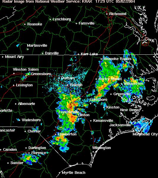
Shortly after takeoff, around the time of the radar picture above, I managed to penetrate the gap between the cells north of Florence. Before I entered the line, a quick "read" of the clouds showed a lighter area along the planned route, with much darker clouds perhaps 10 miles to the north. I encountered IMC and a brief period of level 1 precip, but that was about it. I emerged on the other side of the line with a spectacular view of the backside of the storms. Although I entered IMC again periodically as I skirted the back of the line, I breathed a sigh of relief. The pilot I'd met was making only normal and expected calls, and a quick call to flight service confirmed that the weather extended a bit farther north, but the Richmond area was clear of activity.
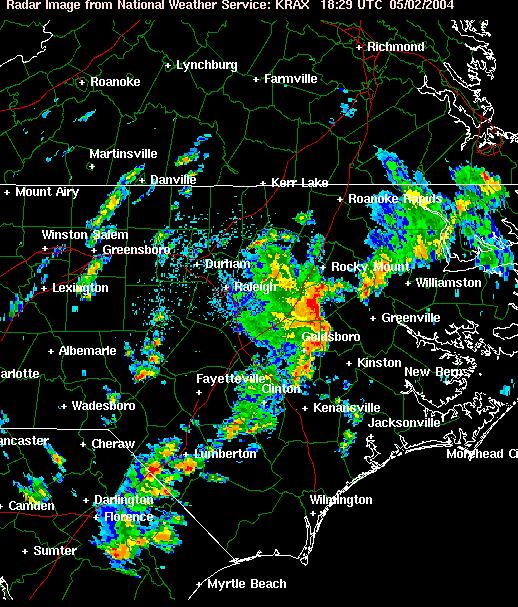
 Around
Lawrenceville, I had to make a few minor deviations around some
towering cumulus clouds, but they topped out at around 12000
feet, and could hardly be considered convective. Of course, such
clouds can pack a punch when it comes to updrafts and turbulence,
so I did everything in my power to avoid them. Just north of
Lawrenceville, I broke out to see only a few scattered to broken
decks at various altitudes below mine. I felt like I'd beaten the
weather, and for the first time since I left Jacksonville, I
celebrated with a little music until it came time to descend for
Richmond.
Around
Lawrenceville, I had to make a few minor deviations around some
towering cumulus clouds, but they topped out at around 12000
feet, and could hardly be considered convective. Of course, such
clouds can pack a punch when it comes to updrafts and turbulence,
so I did everything in my power to avoid them. Just north of
Lawrenceville, I broke out to see only a few scattered to broken
decks at various altitudes below mine. I felt like I'd beaten the
weather, and for the first time since I left Jacksonville, I
celebrated with a little music until it came time to descend for
Richmond.
Last Leg
A check of the radar and another call to flight service revealed that aside from the expected strong low level flow, great weather for the last leg of the trip was virtually guaranteed.
I caught up with the pilot I'd met in Grand Strand and we compared notes before we again departed within a few minutes of one another, enroute to our respective home bases. Unfortunately, departing so close together on virtually the same route caused some separation issues, but I decided to make things a bit more fun (as well as try to top the clouds that kept me in solid IMC at 7000 feet) by requesting a climb to 9000 -- a first for me in this airplane.
Since most airspace transitions from the various approach controls to the ARTCC at 8000 feet, I expected -- and received -- a frequency change to Washington Center, and a clearance direct to Sea Isle VOR on the southern tip of New Jersey. Some minor rerouting a bit later down the line, I managed to touchdown at Old Bridge at 6:10PM, about 5 minutes sooner than planned, and no doubt due to the 185 knot groundspeed I enjoyed during descent. Ah, the perks of riding a strong pressure gradient. :-)
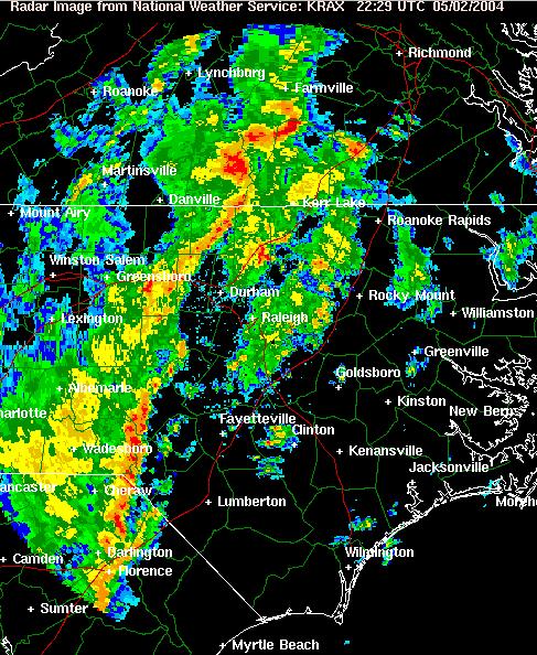
As the Sun continued its march toward the horizon, I managed to pull the car out of the hangar and replace it with the airplane, and start on my way home. As soon as I arrived, I ran upstairs to check the radar for the route, and I was pretty amazed at what I found -- one very nasty line of thunderstorms stretching from Pennsylvania down to Florida. The three radar pictures taken above are from 1730Z (around the time I departed Grand Strand), 1830Z (when I was in the vicinity of Raleigh), and finally, 2030Z, a few minutes after I arrived at home base. Needless to say, that's one hell of a squall line. I got home just in time.
 I
was even more surprised a week or so later while doing research
for this article when I found out, courtesy of the Raleigh, NC
office of the National Weather Service, that an F1 tornado
touched down in central NC shortly after 5PM. Thankfully, I was
long gone from the area before that happened. Many thanks to
Jonathan Blaes and the team that did the case
study.
I
was even more surprised a week or so later while doing research
for this article when I found out, courtesy of the Raleigh, NC
office of the National Weather Service, that an F1 tornado
touched down in central NC shortly after 5PM. Thankfully, I was
long gone from the area before that happened. Many thanks to
Jonathan Blaes and the team that did the case
study.
A Definite "12"
On a scale of 1 to 10, this trip was a 12. At 8.1 hours down and a mere 6.4 hours up the coast, it was a blast the whole way. I broke through a slew of barriers in this aircraft -- highest groundspeed, highest altitude, and shortest time enroute from CRG to 3N6. I also used the skills in weather analysis I'd honed for the last 15 years to arrive at each destination safely in spite of less than ideal conditions. And, most importantly, I got to see my sister take a positive step in her life, which was the whole point to this flight.